
Fayl:Turkestan.png

Size of this preview: 800 × 499 pixels. Başqa çözüm: 320 × 199 pixels | 640 × 399 pixels | 1.024 × 638 pixels | 1.253 × 781 pixels.
Kerçek fayl (1.253 × 781 piksel, fayl büyükligi: 1,28 MB, MIME çeşiti: image/png)

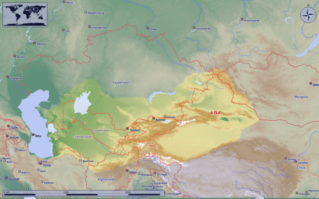
Map of Turkestan with modern state borders; originally made by w:de:Benutzer:Postmann Michael and put into the public domain. (If someone who speaks German could drop by his talk page and thank him for the good work, it would be wonderful.)
Carte du Turkestan avec les frontières des états modernes. Créée par w:de:Benutzer:Postmann Michael qui l'a mise dans le domaine public. (Est-ce que quelqu'un parlant l'allemand peut visiter sa page de discussion pour lui remercier pour ses efforts ?)
| I, the copyright holder of this work, release this work into the public domain. This applies worldwide. In some countries this may not be legally possible; if so: I grant anyone the right to use this work for any purpose, without any conditions, unless such conditions are required by law. |
Faylnıñ keçmişi
Faylnıñ kerekli anki alını körmek içün tarihqa/saatqa basıñız.
| Tarih ve saat | Kiçik resim | En × boy | Qullanıcı | İzaat | |
|---|---|---|---|---|---|
| şimdiki | 22:50, 2020 s. iyünniñ 17 | | 1.253 × 781 (1,28 MB) | MicBy67 | |
| 09:38, 2011 s. sentâbrniñ 15 |  | 1.125 × 748 (662 KB) | Antemister | cropped | |
| 18:50, 2011 s. aprelniñ 3 |  | 1.261 × 879 (853 KB) | MicBy67 | Kleinere Überarbeitung: Farben entkräftet und Grenzkorrektur im Süden | |
| 23:31, 2011 s. fevralniñ 20 |  | 1.261 × 879 (821 KB) | MicBy67 | Überarbeitet. Relief eingefügt und Größe geändert. Das farbige Gebiet innerhalb der gestrichelten Linie stellt das historisch anerkannte Turkestan dar. Die farbigen Gebiete innerhalb der gepunkteten Linie symbolisiert das "größere Turkestan", dem | |
| 03:52, 2005 s. iyünniñ 22 |  | 752 × 592 (36 KB) | Huhsunqu | Better colored version | |
| 13:44, 2005 s. fevralniñ 18 |  | 752 × 592 (36 KB) | Jiminy Krikkitt | Map of Turkestan with modern state borders |
Fayl qullanıluvı
Bu saife qullana bu fayldı:
Umumiy fayl qullanıluvı
Bu vikilerde bu fayldı qullana:
- an.wikipedia.org qullanım
- ar.wikipedia.org qullanım
- azb.wikipedia.org qullanım
- az.wikipedia.org qullanım
- bg.wikipedia.org qullanım
- ca.wikipedia.org qullanım
- cs.wikipedia.org qullanım
- cy.wikipedia.org qullanım
- da.wikipedia.org qullanım
- de.wikipedia.org qullanım
- el.wikipedia.org qullanım
- en.wikiversity.org qullanım
- en.wiktionary.org qullanım
- eo.wikipedia.org qullanım
- es.wikipedia.org qullanım
- eu.wikipedia.org qullanım
- fa.wikiquote.org qullanım
- fi.wikipedia.org qullanım
- fr.wikipedia.org qullanım
- fr.wiktionary.org qullanım
- ga.wikipedia.org qullanım
- he.wikipedia.org qullanım
- hr.wikipedia.org qullanım
- hy.wikipedia.org qullanım
- id.wikipedia.org qullanım
- it.wikipedia.org qullanım
- ja.wikipedia.org qullanım
- ko.wikipedia.org qullanım
- lt.wikipedia.org qullanım
- lv.wikipedia.org qullanım
- mg.wikipedia.org qullanım
- ms.wikipedia.org qullanım
- my.wikipedia.org qullanım
- nl.wikipedia.org qullanım
- no.wikipedia.org qullanım
- oc.wikipedia.org qullanım
- pl.wikipedia.org qullanım
- pl.wiktionary.org qullanım
- pt.wikipedia.org qullanım
- ro.wikipedia.org qullanım
- ru.wikipedia.org qullanım
View more global usage of this file.