
Fayl:LocationRomanEmpire.png
Size of this preview: 800 × 520 pixels. Başqa çözüm: 320 × 208 pixels | 640 × 416 pixels | 1.084 × 705 pixels.
Kerçek fayl (1.084 × 705 piksel, fayl büyükligi: 34 KB, MIME çeşiti: image/png)

|
File:Map of the Roman Empire at its height.svg is a vector version of this file. It should be used in place of this PNG file when not inferior.
File:LocationRomanEmpire.png → File:Map of the Roman Empire at its height.svg
For more information, see Help:SVG. |
 |
| Tasvir |
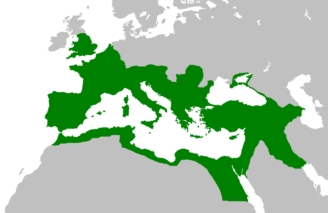
English: Map of the Roman Empire at its height, under Trajan.
Esperanto: Mapo de la Roma Imperio je ĝia plej vasta etendo, sub la imperiestro Trajano.
Español: El Imperio Romano a su máxima extensión, durante el reinado de Trajano.
Suomi: Rooman valtakunta Trajanuksen aikana.
Français : L'Empire romain à son apogée, sous Trajan.
Italiano: Mappa dell'Impero Romano al culmine della sua estensione, sotto Traiano.
日本語: 117年(トラヤヌス帝の時代)のローマ帝国の最大領土
Português: Localização do Império Romano em sua extensão máxima. |
||||||||
| Tarih | |||||||||
| Menba | Previous version | ||||||||
| Yaratıcı | User:Jrockley / User:Kasper Holl | ||||||||
| İzin (Faylnı yañıdan qullanuv) |
|
||||||||
| Other versions |
|

Faylnıñ keçmişi
Faylnıñ kerekli anki alını körmek içün tarihqa/saatqa basıñız.
| Tarih ve saat | Kiçik resim | En × boy | Qullanıcı | İzaat | |
|---|---|---|---|---|---|
| şimdiki | 14:44, 2007 s. iyünniñ 2 | | 1.084 × 705 (34 KB) | Medievalista | Ok, sorry, my mistake... here is the new map |
| 14:42, 2007 s. iyünniñ 2 |  | 1.084 × 705 (34 KB) | Medievalista | Update of the previous map: less of teritory in Africa, withdraw in Britain up to the future Hadrianic wall and improve the trace of the Rhine-Danube frontier | |
| 03:45, 2007 s. fevralniñ 5 |  | 1.084 × 705 (35 KB) | Jrockley | lil bit more Africa, lil less Scandinavia | |
| 03:28, 2007 s. fevralniñ 5 |  | 1.259 × 756 (41 KB) | Jrockley | Much larger version, as faithful as possible | |
| 12:24, 2005 s. avgustnıñ 9 |  | 250 × 175 (8 KB) | Kasper Holl | Map of the location of the Roman Empire at its height, under Trajan. Made from the Blank Map World. |
Fayl qullanıluvı
Bu faylnı qullanğan saife yoq.
Umumiy fayl qullanıluvı
Bu vikilerde bu fayldı qullana:
- en.wikipedia.org qullanım
- he.wikipedia.org qullanım
- hy.wikipedia.org qullanım
- it.wikipedia.org qullanım
- kk.wikipedia.org qullanım