
Fayl:Komargorod pond 2013 G3.jpg

Size of this preview: 800 × 494 pixels. Başqa çözüm: 320 × 198 pixels | 640 × 395 pixels | 1.024 × 633 pixels | 1.280 × 791 pixels | 2.560 × 1.581 pixels | 5.180 × 3.200 pixels.
Kerçek fayl (5.180 × 3.200 piksel, fayl büyükligi: 5,55 MB, MIME çeşiti: image/jpeg)
Faylğa ait qısqa tarif
| Tasvir |
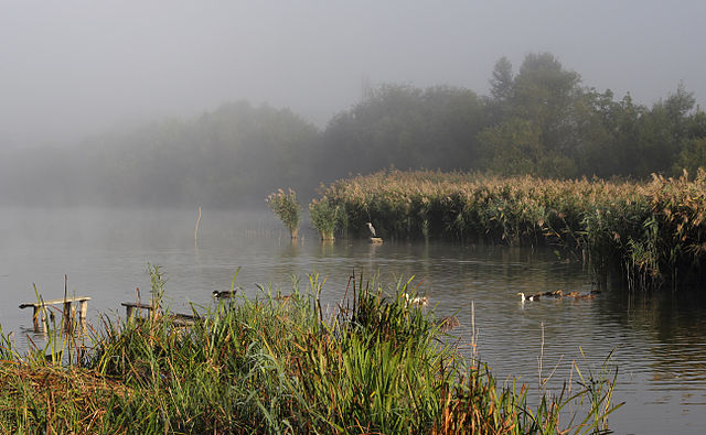
English: Dawn. A pond on the Tomashpilka river in the village of Komargorod. The first beams of the sun and fog over water. Tomashpil Raion of Vinnytsia Oblast. Ukraine.
Español: Amanecer. Vista de un estanque a lo largo del río Tomashpilka a la altura del pueblo de Komargorod, Tomashpil, Óblast de Vínnytsia, Ucrania.
Polski: Świt nad stawem na rzece Tomaszpilka we wsi Komargród w rejonie tomaszpolskim obwodu winnickiego na Ukrainie.
Русский: Рассвет. Пруд на реке Томашполька в селе Комаргород. Томашпольский район Винницкой области, Украина.
Українська: Світанок в Комаргороді. Ставок на річці Томашпілька в центрі села. Томашпільський район Вінницької області.
Čeština: První rozbřesk dne na řece Tomašpilka u vesnice Komargorod ve Vinnycké oblasti na Ukrajině.
Magyar: Napfelkelte a duzzasztott Tomaspilka-folyón Komarhorod közelében (Vinnicjai terület, Ukrajna)
Македонски: Магловита бара на реката Томашпилка во мугри. Комаргород, Виничка област. Украина.
Português: Amanhecer. Vista de uma lagoa ao longo do rio Tomashpilka, perto da vila Komargorod, município de Tomashpil, região de Vinnitsa, Ucrânia. |
||
| Tarih | |||
| Menba | Öz işi | ||
| Yaratıcı | George Chernilevsky | ||
| İzin (Faylnı yañıdan qullanuv) |
|
| Camera location | | View this and other nearby images on: OpenStreetMap |
|---|
Assessment
|
This image was selected as picture of the day on Wikimedia Commons for 11 October 2016. It was captioned as follows: English: Dawn. A pond on the Tomashpilka river in the village of Komargorod. The first beams of the sun and fog over water. Tomashpil Raion of Vinnytsia Oblast. Ukraine. Other languages:
Čeština: První rozbřesk dne na řece Tomašpilka u vesnice Komargorod ve Vinnycké oblasti na Ukrajině. English: Dawn. A pond on the Tomashpilka river in the village of Komargorod. The first beams of the sun and fog over water. Tomashpil Raion of Vinnytsia Oblast. Ukraine. Español: Amanecer. Vista de un estanque a lo largo del río Tomashpilka a la altura del pueblo de Komargorod, Tomashpil, Óblast de Vínnytsia, Ucrania. Magyar: Napfelkelte a duzzasztott Tomaspilka-folyón Komarhorod közelében (Vinnicjai terület, Ukrajna) Polski: Świt nad stawem na rzece Tomaszpilka we wsi Komargród w rejonie tomaszpolskim obwodu winnickiego na Ukrainie. Português: Amanhecer. Vista de uma lagoa ao longo do rio Tomashpilka, perto da vila Komargorod, município de Tomashpil, região de Vinnitsa, Ucrânia. Македонски: Магловита бара на реката Томашпилка во мугри. Комаргород, Виничка област. Украина. Русский: Рассвет. Пруд на реке Томашполька в селе Комаргород. Томашпольский район Винницкой области, Украина. Українська: Світанок в Комаргороді. Ставок на річці Томашпілька в центрі села. Томашпільський район Вінницької області. |
Faylnıñ keçmişi
Faylnıñ kerekli anki alını körmek içün tarihqa/saatqa basıñız.
| Tarih ve saat | Kiçik resim | En × boy | Qullanıcı | İzaat | |
|---|---|---|---|---|---|
| şimdiki | 21:29, 2015 s. mayısnıñ 25 | | 5.180 × 3.200 (5,55 MB) | George Chernilevsky | User created page with UploadWizard |
Fayl qullanıluvı
Bu saife qullana bu fayldı:
Umumiy fayl qullanıluvı
Bu vikilerde bu fayldı qullana:
- ba.wikipedia.org qullanım
- be-tarask.wikipedia.org qullanım
- ceb.wikipedia.org qullanım
- cs.wikipedia.org qullanım
- cv.wikipedia.org qullanım
- en.wikipedia.org qullanım
- es.wikipedia.org qullanım
- et.wikipedia.org qullanım
- fa.wikipedia.org qullanım
- fr.wikipedia.org qullanım
- hu.wikipedia.org qullanım
- hy.wikipedia.org qullanım
- id.wikipedia.org qullanım
- it.wikipedia.org qullanım
- ka.wikipedia.org qullanım
- ko.wikipedia.org qullanım
- lbe.wikipedia.org qullanım
- lmo.wiktionary.org qullanım
- mk.wikipedia.org qullanım
- myv.wikipedia.org qullanım
- os.wikipedia.org qullanım
- pl.wikipedia.org qullanım
- pt.wikipedia.org qullanım
- ro.wikipedia.org qullanım
- ru.wikipedia.org qullanım
- ru.wikinews.org qullanım
- sah.wikipedia.org qullanım
- sq.wikipedia.org qullanım
- tt.wikipedia.org qullanım
- uk.wikipedia.org qullanım
- vi.wikipedia.org qullanım
- www.wikidata.org qullanım
- zh.wikipedia.org qullanım