
Fayl:Bois du Cazier 2.jpg

Kerçek fayl (4.304 × 2.860 piksel, fayl büyükligi: 12,88 MB, MIME çeşiti: image/jpeg)
|

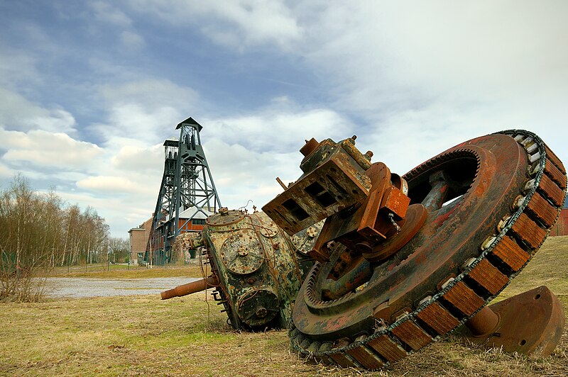
This image was selected as picture of the day on Wikimedia Commons for 16 June 2009. It was captioned as follows: Other languages:
Dansk: Den nedlagte kulmine Bois du Cazier i Belgien, stedet for Belgiens største mineulykke i 1956. Deutsch: Das stillgelegte Kohlenbergwerk Bois du Cazier in Belgien Español: Restos de la mina de carbón de Bois du Cazier tras el desastre de Marcinelle, Charleroi, Bélgica. Français : Le site du bois du Cazier Magyar: A Bois du Cazier szénbánya maradványai Nederlands: overblijfselen van de Mijnramp van Marcinelle in 1956, de grootste Belgische mijnramp ooit en een van de grootste uit de Europese mijnbouwgeschiedenis. Op de achtergrond een schachtblok. Polski: Ruiny kopalni węgla Bois du Cazier w Marcinelle w Belgii. Slovenščina: Prizor iz bivšega belgijskega premogovnika Bois du Cazier, danes preurejenega v tehnični muzej Македонски: Остатоци од рудникот за јаглен Казие во Белгија, настрадан во катастрофа. Русский: Последствия аварии 1956 года на шахте Буа-де-Казьер в Марсинелле, недалеко от Шарлеруа (Бельгия) |
Faylğa ait qısqa tarif
| Tasvir |
English: Mining accident of Marcinelle
Français : Le site du bois du Cazier
Nederlands: Mijnramp van Marcinelle
Deutsch: Bois du Cazier
Italiano: Disastro di Marcinelle
Lëtzebuergesch: Bois du Cazier
Polski: Pozostałości po kopalni w Marcinelle, Belgia
Walon : Rascråwe do Bwès do Cazî
Suomi: Marcinellen kaivosten jäänteitä. |
||||||||||
| Tarih | (28 fevral 2009, according to Exif data) | ||||||||||
| Menba |
|
||||||||||
| Yaratıcı | Luc Viatour | ||||||||||
| İzin (Faylnı yañıdan qullanuv) |
I, Luc Viatour, the copyright holder of this work, hereby publishes it under the following licenses:
This file is licensed under the Creative Commons Attribution-Share Alike 2.5 Generic, 2.0 Generic and 1.0 Generic license. Attribution: I, Luc Viatour
İstedigiñiz lisansnı seçebilirsiñiz. |


| Camera location | | View this and other nearby images on: OpenStreetMap |
|---|
Faylnıñ keçmişi
Faylnıñ kerekli anki alını körmek içün tarihqa/saatqa basıñız.
| Tarih ve saat | Kiçik resim | En × boy | Qullanıcı | İzaat | |
|---|---|---|---|---|---|
| şimdiki | 10:56, 2009 s. martnıñ 9 | | 4.304 × 2.860 (12,88 MB) | Lviatour | {{Information |Description={{en|1=caz}} {{fr|1=c}} |Source=travail personnel (own work) |Author=Lviatour |Date= |Permission= |other_versions= }} <!--{{ImageUpload|full}}--> |
Fayl qullanıluvı
Bu saife qullana bu fayldı:
Umumiy fayl qullanıluvı
Bu vikilerde bu fayldı qullana:
- az.wikipedia.org qullanım
- bn.wikipedia.org qullanım
- ca.wikipedia.org qullanım
- cs.wikipedia.org qullanım
- cv.wikipedia.org qullanım
- da.wikipedia.org qullanım
- de.wikipedia.org qullanım
- en.wikipedia.org qullanım
- en.wikivoyage.org qullanım
- eo.wikipedia.org qullanım
- es.wikipedia.org qullanım
- fa.wikipedia.org qullanım
- fi.wikipedia.org qullanım
- fr.wikipedia.org qullanım
- Utilisateur:Fralambert
- Utilisateur:Jmh2o
- Utilisateur:ComputerHotline
- Bois du Cazier
- Utilisateur:Lamiot
- Utilisateur:Lviatour/Images/Images de qualité
- Wikipédia:Boîtes utilisateur culture
- Utilisateur:Rundvald
- Patrimoine industriel
- Utilisateur:Smiley.86
- Utilisateur:FrankyLeRoutier
- Utilisateur:LucasD/Moi
- Projet:Impression/Quality images/17
View more global usage of this file.