
Fayl:Arnhem Land map.png

Bu baqıp çıquvnıñ büyükligi: 800 × 584 pixels. Başqa çözüm: 320 × 233 pixels | 640 × 467 pixels | 1.024 × 747 pixels | 1.280 × 934 pixels | 1.615 × 1.178 pixels.
Kerçek fayl (1.615 × 1.178 piksel, fayl büyükligi: 1,45 MB, MIME çeşiti: image/png)
Faylğa ait qısqa tarif
| Tasvir |
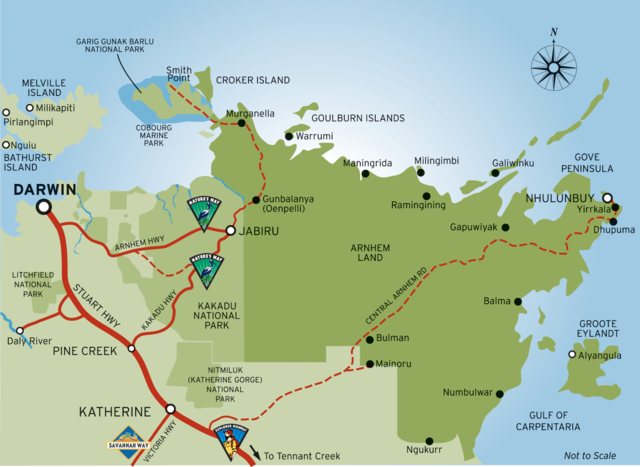
English: Map of Arnhem Land, Northern Territory |
| Tarih | |
| Menba | Nigel Malone |
| Yaratıcı | Nigel Malone |
Litsenziyalama
This file is licensed under the Creative Commons Attribution-Share Alike 4.0 International, 3.0 Unported, 2.5 Generic, 2.0 Generic and 1.0 Generic license.
- Şunı yapmaq serbestsiñiz:
- paylaşmaq – eserni kopiyalamaq, tarqatmaq ve başqasına bermek
- remiks etmek – deñiştirip uyğunlaştırmaq
- Şu şartlar astında:
- atıf – You must give appropriate credit, provide a link to the license, and indicate if changes were made. You may do so in any reasonable manner, but not in any way that suggests the licensor endorses you or your use.
- aynı şekilde paylaşuv – If you remix, transform, or build upon the material, you must distribute your contributions under the same or compatible license as the original.
Original upload log
| This file was imported from Wikivoyage WTS. |
The original description page was here. All following user names refer to wts.wikivoyage-old.
- 2008-11-24 06:26 (WT-shared) Lex[dead link] 1615×1178 (1521510 bytes) {{Imagecredit|credit=Nigel Malone|captureDate=2005|location=NT|source=Nigel Malone|caption=Map of Arnhem Land|description=Map of Arnhem Land (Import from wikitravel.org/shared)
Faylnıñ keçmişi
Faylnıñ kerekli anki alını körmek içün tarihqa/saatqa basıñız.
| Tarih ve saat | Kiçik resim | En × boy | Qullanıcı | İzaat | |
|---|---|---|---|---|---|
| şimdiki | 21:53, 2012 s. noyabrniñ 17 | | 1.615 × 1.178 (1,45 MB) | MGA73bot2 | {{BotMoveToCommons|wts.oldwikivoyage|year={{subst:CURRENTYEAR}}|month={{subst:CURRENTMONTHNAME}}|day={{subst:CURRENTDAY}}}} == {{int:filedesc}} == {{Information |description=Map of Arnhem Land. Map of Arnhem Land, Northern Territory * Map of: Northern ... |
Fayl qullanıluvı
Bu saife qullana bu fayldı:
Umumiy fayl qullanıluvı
Bu fayl aşağıdaki başqa vikilerde qullanıla:
- en.wikipedia.org leyhasında qullanıluvı
- en.wikivoyage.org leyhasında qullanıluvı
- hu.wikipedia.org leyhasında qullanıluvı
- kk.wikipedia.org leyhasında qullanıluvı
- ky.wikipedia.org leyhasında qullanıluvı
- uk.wikipedia.org leyhasında qullanıluvı