
Fayl:2010-10-09 Arlbergtunnel.jpg
Size of this preview: 800 × 533 pixels. Başqa çözüm: 320 × 213 pixels | 640 × 427 pixels | 1.024 × 683 pixels | 1.280 × 853 pixels | 2.560 × 1.707 pixels | 3.888 × 2.592 pixels.
Kerçek fayl (3.888 × 2.592 piksel, fayl büyükligi: 3,7 MB, MIME çeşiti: image/jpeg)
Faylğa ait qısqa tarif
| Tasvir |
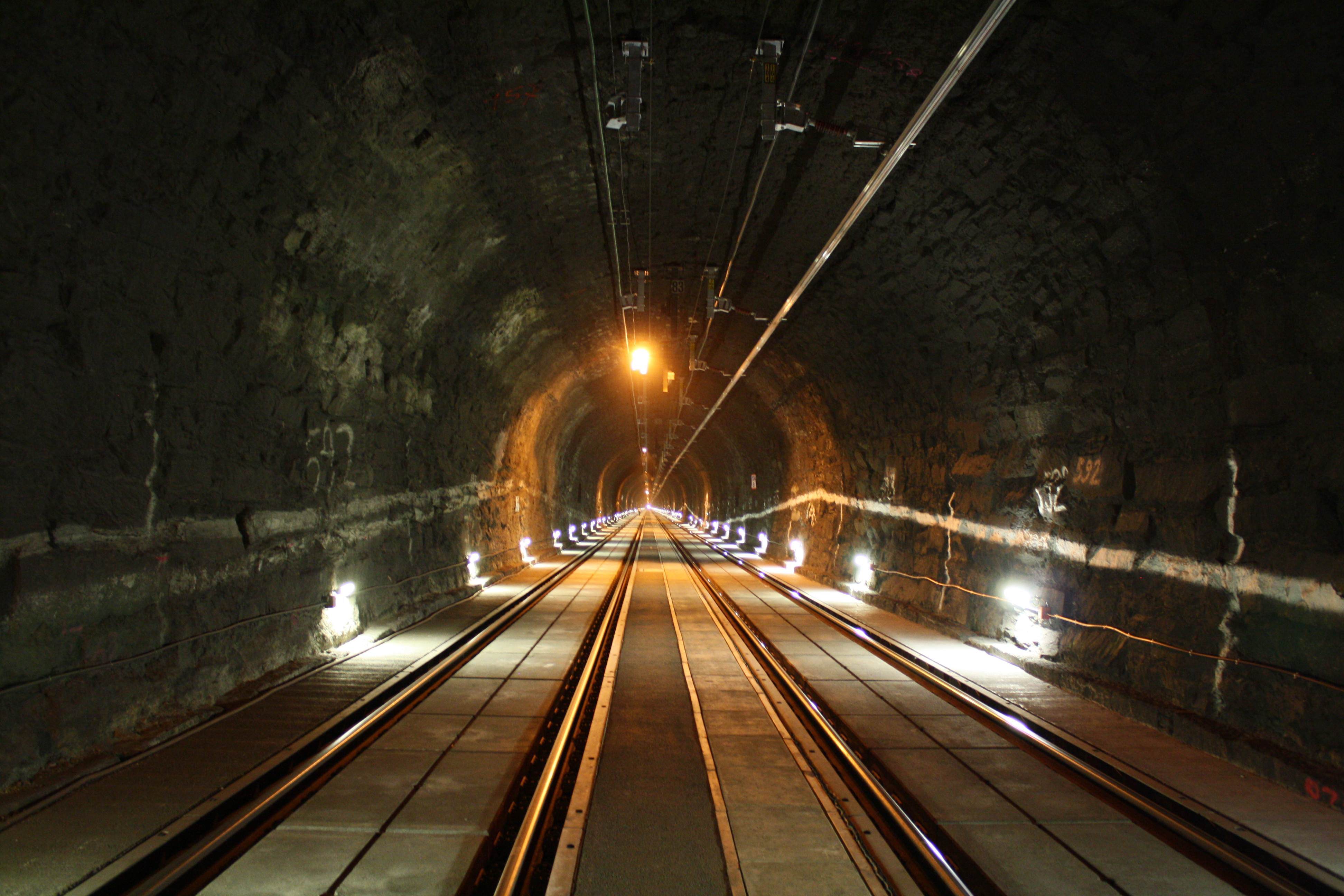
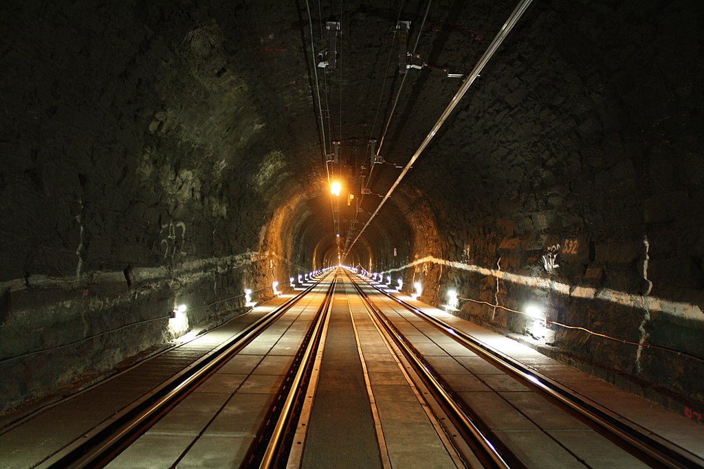
Čeština: Arlberský tunel na kilometru 104,8, pohled směrem k Langen am Arlberg.
Dansk: Arlbergtunnelen ved 104,8 km i et centreret perspektiv i retning mod Langen am Arlberg. I forbindelse med omfattende renoveringsarbejde i jernbanetunnelen blev den forsynet med et pladespor, så almindelige køretøjer kunne komme ind i nødstilfælde. For at få større frihøjde blev de nye spor sænket, og foroven blev køreledningerne ændret til strømskinner. I det sydlige (venstre) spor er strømskinnen endnu ikke monteret.
Deutsch: Arlbergtunnel bei km 104,8 mit Blick zum über 5 km entfernten Westportal. Im Zuge umfangreicher Sanierungsarbeiten wurde der Arlbergtunnel mit einer festen Fahrbahn ausgerüstet um auch Straßenfahrzeugen im Notfall die Einfahrt in den Tunnel zu ermöglichen. Um ein größeres Lichtraumprofil zu erhalten wurde die neue Fahrbahn abgesenkt sowie die Oberleitung durch Stromschienen ersetzt. Auf dem südlichen Gleis (links) fehlt die Stromschiene noch.
English: Arlberg tunnel at km 104.8, perspective view in the direction of Langen am Arlberg. In the course of extensive rehabilitation works the Arlberg tunnel was equipped with a slab track to enable road vehicles entering the tunnel in case of an emergency. To get a larger clearance gauge the new tracks were lowered and the overhead lines were substituted by overhead conductor rails. At the southern track (left) the conductor rail is not yet installed.
Español: Vista hacia Langen am Arlberg en el km 104,8 del túnel Arlberg. Durante unas exhaustivas obras de rehabilitación se instaló una vía de hormigón para permitir que los vehículos de ruedas entrasen al túnel en caso de emergencia. Para lograr un ancho mayor las nuevas vías se rebajaron y sustituyeron las catenarias de cable superiores por otras de raíl (la de la izquierda no está aún instalada).
Français : Le tunnel l'Arlberg au kilomètre 104,8, en regardant vers Langen am Arlberg. Ce tunnel a été lourdement réaménagé : Le sol a été décaissé, les rails insérés dans un parapet, et sous la voute des profils aériens de contact (appelés également caténaire rigide) remplacent les caténaires. L'objectif de ces travaux est de rendre le tunnel accessible à un véhicule de secours en cas d'accident. Dans cette vue, la caténaire rigide de la voie de droite n'est pas encore posée.
Italiano: Il Traforo dell'Arlberg, in Austria, visto in prospettiva in direzione di Langen am Arlberg, al km 104,8.
日本語: アールベルクトンネル内、104.8キロポスト付近。ランゲン・アム・アールベルクの方向を向いて撮影。同トンネルは大規模な改修工事によってスラブ軌道が敷設され、緊急時に自動車が入れるようになった。また車両限界を拡大するために軌道面が掘り下げられ、架空電車線は剛体架線に交換された。撮影時、南側(左)の線路にはまだ架線が張られていない。
Македонски: Арлбершкиот железнички тунел во Австрија.
Nederlands: De Arlbergspoortunnel tijdens renovatie, gefotografeerd richting Langen am Arlberg, Oostenrijk.
中文(简体):奥地利阿尔贝格铁路隧道 |
| Tarih | |
| Menba | Öz işi |
| Yaratıcı | Siegele Roland |
| Camera location | | View this and other nearby images on: OpenStreetMap |
|---|
Assessment
|

This image was selected as picture of the day on Wikimedia Commons for 22 February 2011. It was captioned as follows: English: Arlberg tunnel at km 104.8, perspective view in the direction of Langen am Arlberg. In the course of extensive rehabilitation works the rail tunnel was equipped with a slab track to enable road vehicles entering the tunnel in case of an emergency. To get a larger clearance gauge the new tracks were lowered and the overhead lines were substituted by overhead conductor rails. At the southern track (left) the conductor rail is not yet installed. Other languages:
Dansk: Arlbergtunnelen ved 104,8 km i et centreret perspektiv i retning mod Langen am Arlberg. I forbindelse med omfattende renoveringsarbejde i jernbanetunnelen blev den forsynet med et pladespor, så almindelige køretøjer kunne komme ind i nødstilfælde. For at få større frihøjde blev de nye spor sænket, og foroven blev køreledningerne ændret til strømskinner. I det sydlige (venstre) spor er strømskinnen endnu ikke monteret. Deutsch: Arlbergtunnel bei km 104,8, Blickrichtung Langen am Arlberg. Im Zuge umfangreicher Sanierungsarbeiten wurde der Arlbergtunnel mit einer festen Fahrbahn ausgerüstet um auch Straßenfahrzeugen im Notfall die Einfahrt in den Tunnel zu ermöglichen. Um ein größeres Lichtraumprofil zu erhalten wurde die neue Fahrbahn abgesenkt sowie die Oberleitung durch Stromschienen ersetzt. Auf dem südlichen Gleis (links) fehlt die Stromschiene noch. English: Arlberg tunnel at km 104.8, perspective view in the direction of Langen am Arlberg. In the course of extensive rehabilitation works the rail tunnel was equipped with a slab track to enable road vehicles entering the tunnel in case of an emergency. To get a larger clearance gauge the new tracks were lowered and the overhead lines were substituted by overhead conductor rails. At the southern track (left) the conductor rail is not yet installed. Español: Vista hacia Langen am Arlberg en el km 104,8 del túnel Arlberg. Durante unas exhaustivas obras de rehabilitación se instaló una vía de hormigón para permitir que los vehículos de ruedas entrasen al túnel en caso de emergencia. Para lograr un ancho mayor las nuevas vías se rebajaron y sustituyeron las catenarias de cable superiores por otras de raíl (la de la izquierda no está aún instalada). Français : Le tunnel l'Arlberg au kilomètre 104,8, en regardant vers Langen am Arlberg. Ce tunnel a été lourdement réaménagé : Le sol a été décaissé, les rails insérés dans un parapet, et sous la voute des rails d'alimentation remplacent les caténaires. L'objectif de ces travaux est de rendre le tunnel accessible à un véhicule de secours en cas d'accident. Dans cette vue, le rail d'alimentation de la voie de droite n'est pas encore posé. Italiano: Il tunnel del traforo ferroviario dell'Arlberg, in Austria, visto in prospettiva in direzione di Klösterle/Langen am Arlberg, al km 104,8. Magyar: A 10,648 kilométer hosszú Arlberg vasúti alagút (Ausztria) Nederlands: De Arlbergspoortunnel tijdens renovatie, gefotografeerd richting Langen am Arlberg, Oostenrijk. Português: Túnel Alberg (Arlbergtunnel), Áustria Македонски: Арлбершкиот железнички тунел во Австрија. 日本語: アールベルクトンネル内、104.8キロポスト付近。ランゲン・アム・アールベルクの方向を向いて撮影。同トンネルは大規模な改修工事によってスラブ軌道が敷設され、緊急時に自動車が入れるようになった。また車両限界を拡大するために軌道面が掘り下げられ、架空電車線は剛体架線に交換された。撮影時、南側(左)の線路にはまだ架線が張られていない。 中文: 奥地利阿尔贝格铁路隧道 |
Litsenziyalama
This file is licensed under the Creative Commons Attribution-Share Alike 3.0 Austria license.
- Azatsıñız:
- paylaşuv – qopyaluv, dağıtuv ve iletüv
- remiks etüv – uyğunlaştıruv
- Bu şartlar astında:
- attribution – You must give appropriate credit, provide a link to the license, and indicate if changes were made. You may do so in any reasonable manner, but not in any way that suggests the licensor endorses you or your use.
- aynı şekilde paylaşuv – If you remix, transform, or build upon the material, you must distribute your contributions under the same or compatible license as the original.

Faylnıñ keçmişi
Faylnıñ kerekli anki alını körmek içün tarihqa/saatqa basıñız.
| Tarih ve saat | Kiçik resim | En × boy | Qullanıcı | İzaat | |
|---|---|---|---|---|---|
| şimdiki | 21:52, 2010 s. noyabrniñ 13 | | 3.888 × 2.592 (3,7 MB) | Hukkepakk | {{Information |Description={{de|1=Arlbergtunnel bei km 104,8. Blickrichtung Langen am Arlberg.}} {{en|1=Arlbergtunnel at km 104,8. Viewing direction Langen am Arlberg.}} |Source={{own}} |Author=Siegele Roland |Date=2010-10-09 |Perm |
Fayl qullanıluvı
Bu saife qullana bu fayldı:
Umumiy fayl qullanıluvı
Bu vikilerde bu fayldı qullana:
- ba.wikipedia.org qullanım
- be-tarask.wikipedia.org qullanım
- be.wikipedia.org qullanım
- bn.wikipedia.org qullanım
- br.wikipedia.org qullanım
- cs.wikipedia.org qullanım
- cv.wikipedia.org qullanım
- de.wikipedia.org qullanım
- en.wikipedia.org qullanım
- fa.wikipedia.org qullanım
- fi.wikipedia.org qullanım
- fr.wikipedia.org qullanım
- hu.wikipedia.org qullanım
- id.wikipedia.org qullanım
- it.wikipedia.org qullanım
- ja.wikipedia.org qullanım
- ko.wikipedia.org qullanım
- lbe.wikipedia.org qullanım
- mk.wikipedia.org qullanım
- nl.wikipedia.org qullanım
- no.wikipedia.org qullanım
- os.wikipedia.org qullanım
- pl.wikipedia.org qullanım
- pt.wikipedia.org qullanım
- ru.wikipedia.org qullanım
- ru.wikinews.org qullanım
View more global usage of this file.