
Fayl:Waldemmental Juli2007.jpg
Size of this preview: 800 × 197 pixels. Başqa çözüm: 320 × 79 pixels | 640 × 158 pixels | 1.024 × 252 pixels | 1.280 × 315 pixels | 5.078 × 1.250 pixels.
Kerçek fayl (5.078 × 1.250 piksel, fayl büyükligi: 2,33 MB, MIME çeşiti: image/jpeg)
| Tasvir |
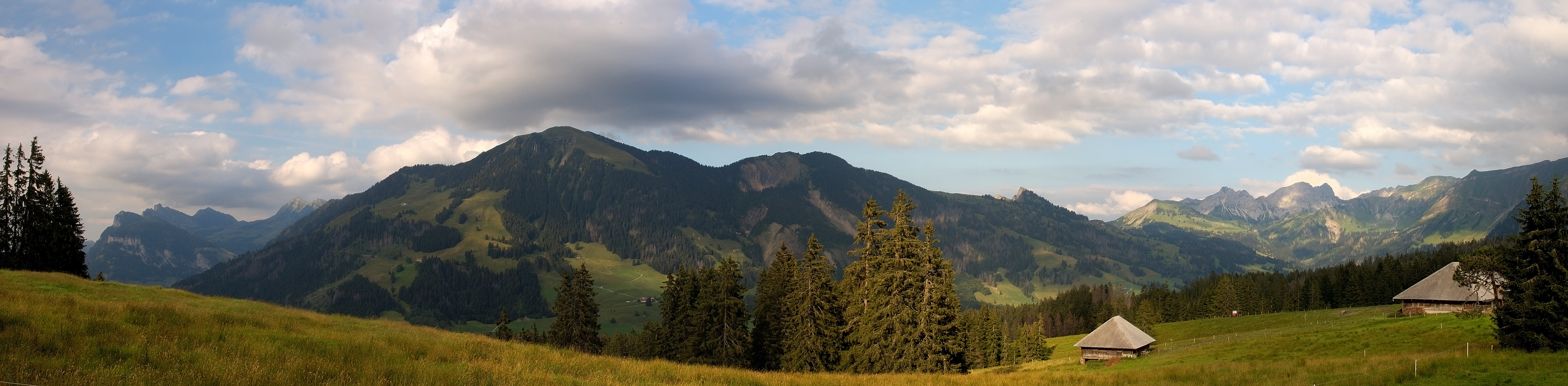
Deutsch: Blick von Salwiden auf die Berge des Waldemmentals (Mariental) (links: Schwändeliflue und Fürstein, mittig: Hagleren und Nünalpstock, rechts: Glaubenbielenpass), Entlebuch, Schweiz
English: View from Salwiden, above Sörenberg, to the mountains of the valley of Waldemme (Mariental) (left side: Schwändeliflue and Fürstein, middle: Hagleren and Nünalpstock, right side: Glaubenbielenpass), Entlebuch region, Switzerland
Français : Vue de Salwiden vers les montagnes entourant la vallée de Waldemme. A gauche: le Schwändeliflue et le Fürstein; au centre: le Hagleren et le Nünalpstock; à droite: le col de Glaubenbielen. Région d'Entlebuch, Suisse.
Português: Vista de Salwiden para as montanhas do vale de Waldemme (à esquerda: Schwändeliflue e Fürstein; ao meio: Hagleren e Nünalpstock; à direita: Glaubenbielenpass), região de Entlebuch, Suíça
Camera: Nikon D50Lens: Tamron 18-200mm F/3,5-6,3 XR Di II LD Aspherical [IF] MACRO |
| Tarih | |
| Menba | Öz işi |
| Yaratıcı | Simon Koopmann |
| İzin (Faylnı yañıdan qullanuv) |
Everybody can download it and use it for his own purposes. By publishing or other public usage of the image the author should be mentioned.
This file is licensed under the Creative Commons Attribution-Share Alike 2.0 Germany license.
 |
| Other versions | Derivative works of this file: Sörenberg banner.jpg |
| Camera location | | View this and other nearby images on: OpenStreetMap |
|---|
Assessment
This image was selected as picture of the day on Wikimedia Commons for 27 December 2009. It was captioned as follows: English: View from Salwiden above Sörenberg to the mountains of the valley of Waldemme (Mariental) in the Entlebuch region of Switzerland. Other languages:
Bosanski: Pogled iz Salwiden-a izbad Sörenberg-a na planine doline Waldemme (Mariental) u švicarskom kotaru Entlebuch Čeština: Pohled ze Salwidenu nad Sörenbergem na hory v údolí Mariental ve švýcarském okrese Entlebuch Dansk: Udsigt fra Salwiden over Sörenberg til bjergene omkring Waldemme-dalen (Mariental) i Entlebuch-regionen i Schweiz. Deutsch: Blick von Salwiden über Sörenberg zu den Bergen des Tals von Waldemme (Mariental) im Entlebuch. English: View from Salwiden above Sörenberg to the mountains of the valley of Waldemme (Mariental) in the Entlebuch region of Switzerland. Español: Vista desde Salwiden sobre Sörenberg de las montañas del valle de Waldemme (Mariental) en la región Entlebuch de Suiza. Italiano: Il panorama da Salwiden, sopra il villaggio di Sörenberg nel distretto di Entlebuch, in Svizzera. Sulla destra si può vedere il Glaubenbühlpass che collega il Canton Lucerna al Canton Obvaldo. Magyar: A svájci Waldemme völgy hegyeinek látképe a Salwidenről nézve. Nederlands: Gezicht op de bergen rond de vallei van de rivier de Waldemme (Mariental) vanaf de alpenhut Salwiden in het veengebied Sörenberg in het Centraal-Zwitserse district Entlebuch Português: Vista de Salwiden para as montanhas do Vale de Waldemme, região de Entlebuch, Suíça. Македонски: Поглед од Залвиден над Зеренберг на планините и долината Валдеме (Маринтал) во регионот Ентлебух, Швајцарија. বাংলা : সুইজারল্যান্ডের সোরেনবার্গের ওপর দিয়ে দৃশ্যমান ওয়ালডেম উপত্যকার পাহাড়ের দৃশ্য। 中文: 瑞士恩特勒布赫风景 中文(繁體): 瑞士恩特勒布赫風景 |
|

This image has been assessed using the Quality image guidelines and is considered a Quality image.
|
Faylnıñ keçmişi
Faylnıñ kerekli anki alını körmek içün tarihqa/saatqa basıñız.
| Tarih ve saat | Kiçik resim | En × boy | Qullanıcı | İzaat | |
|---|---|---|---|---|---|
| şimdiki | 16:47, 2007 s. sentâbrniñ 5 | 5.078 × 1.250 (2,33 MB) | Simonizer | {{Location|46|48|53.88|N|8|0|36.00|E}} {{Information |Description={{en|View from Salwiden to the mountains of the valley of Waldemme (left side: Schwändeliflue and Fürstein, middle: Hagleren und Nünalpstock, right side: Glaubielenpass), Entlebuch regio |
Fayl qullanıluvı
Bu saife qullana bu fayldı:
Umumiy fayl qullanıluvı
Bu vikilerde bu fayldı qullana:
- ba.wikipedia.org qullanım
- bn.wikipedia.org qullanım
- cv.wikipedia.org qullanım
- de.wikipedia.org qullanım
- en.wikipedia.org qullanım
- eo.wikipedia.org qullanım
- fr.wikipedia.org qullanım
- hu.wikipedia.org qullanım
- id.wikipedia.org qullanım
- ko.wikipedia.org qullanım
- krc.wikipedia.org qullanım
- lbe.wikipedia.org qullanım
- ln.wikipedia.org qullanım
- mg.wikipedia.org qullanım
- mk.wikipedia.org qullanım
- nn.wikipedia.org qullanım
- os.wikipedia.org qullanım
- pam.wikipedia.org qullanım
- pl.wikipedia.org qullanım
- pt.wikipedia.org qullanım
- ru.wikipedia.org qullanım
- ru.wikinews.org qullanım
- sah.wikipedia.org qullanım
- uk.wikipedia.org qullanım
- vi.wikipedia.org qullanım
- xal.wikipedia.org qullanım
- zh.wikipedia.org qullanım