
Fayl:Sverdlovskaya-pozkarta.png

Size of this preview: 514 × 599 pixels. Başqa çözüm: 206 × 240 pixels | 412 × 480 pixels | 659 × 768 pixels | 878 × 1.024 pixels | 1.757 × 2.048 pixels | 3.675 × 4.284 pixels.
Kerçek fayl (3.675 × 4.284 piksel, fayl büyükligi: 224 KB, MIME çeşiti: image/png)
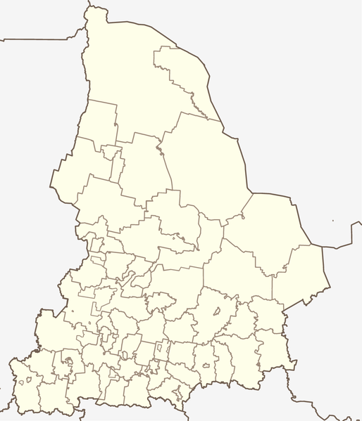
Map of Sverdlovsk Oblast, Russia, in the Mercator projection. Cropped by 1 degree lines (57° - 67° E, 56° - 62° N). Less or more suitable for PosMap.
According to the author (see Discussion:Koryakov Yuri) made on the basis of that map (Open Budget Regions of Russia project) and maps from CD "Все карты России. Ингит" (CD "Аll maps of Russia", Ingit, LLC)
Faylğa ait qısqa tarif
| Tasvir | Map of Sverdlovskaya oblast (Russia), in the Mercator projection. |
| Tarih | |
| Menba | self-made (based on the maps by Ingit, LLC and Open Budget Regions of Russia project) |
| Yaratıcı | Koryakov Yuri |
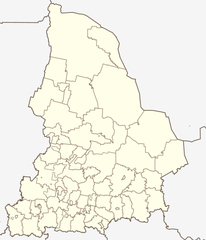
| Other versions | Derivative works of this file: Sverdlovskaya-Artinsky-pozkarta.png |
Litsenziyalama
| I, the copyright holder of this work, release this work into the public domain. This applies worldwide. In some countries this may not be legally possible; if so: I grant anyone the right to use this work for any purpose, without any conditions, unless such conditions are required by law. |
Faylnıñ keçmişi
Faylnıñ kerekli anki alını körmek içün tarihqa/saatqa basıñız.
| Tarih ve saat | Kiçik resim | En × boy | Qullanıcı | İzaat | |
|---|---|---|---|---|---|
| şimdiki | 12:05, 2019 s. sentâbrniñ 17 | | 3.675 × 4.284 (224 KB) | Вальдимар | + селище Тайожний |
| 09:51, 2019 s. sentâbrniñ 17 |  | 3.675 × 4.284 (223 KB) | Вальдимар | підправив кордон Махньовського МО | |
| 09:00, 2019 s. sentâbrniñ 6 |  | 3.675 × 4.284 (223 KB) | Вальдимар | Оновлено кордони міських округів | |
| 08:50, 2012 s. noyabrniñ 29 |  | 3.675 × 4.284 (224 KB) | Botinko | Границы городских округов, утвержденные в 2005-2007 годах | |
| 16:26, 2010 s. martnıñ 22 |  | 2.237 × 2.608 (71 KB) | Const st | убрал рамку | |
| 16:15, 2010 s. martnıñ 22 |  | 2.237 × 2.608 (56 KB) | Const st | цвета и линии привёл в соответствие с принятыми нормами | |
| 08:27, 2007 s. mayısnıñ 25 |  | 2.237 × 2.608 (74 KB) | Koryakov Yuri | {{Information |Description= |Source=self-made |Date=May 2007 |Author= Koryakov Yuri |other_versions= }} |
Fayl qullanıluvı
Bu 77 saifeler qullana bu fayldı:
- Alapayevsk
- Aramil
- Arti
- Artömovskiy
- Asbest (şeer)
- Atig
- Açit
- Baykalovo (Sverdlovsk vilâyeti)
- Beloyarskiy (Sverdlovsk vilâyeti)
- Berözovskiy (şeer, Sverdlovsk vilâyeti)
- Bisert
- Bogdanoviç (şeer)
- Degtârsk
- Drujinino
- Gari (Sverdlovsk vilâyeti)
- Gornouralskiy
- Kamensk-Uralskiy
- Kamışlov
- Karpinsk
- Kaçkanar
- Kirovgrad
- Krasnoturyinsk
- Krasnoufimsk
- Krasnouralsk
- Kuşva
- Lesnoy (şeer)
- Mahnövo
- Malışeva (Sverdlovsk vilâyeti)
- Martüş
- Mihaylovsk (Sverdlovsk vilâyeti)
- Natalyinsk
- Nevyansk
- Nijniy Tagil
- Nijniye Sergi
- Nijnâya Salda
- Nijnâya Tura
- Novaya Lâlâ
- Novouralsk
- Pelım (şeer şeklinde qasaba)
- Pervouralsk
- Pionerskiy (İrbitskoye)
- Polevskoy
- Pışma (Sverdlovsk vilâyeti)
- Reftinskiy
- Rej
- Revda (şeer)
- Serov (şeer)
- Severouralsk
- Sosva (Sosva şeer bölgesi)
- Sredneuralsk
- Staroutkinsk
- Suhoy Log (şeer)
- Svobodnıy (Sverdlovsk vilâyeti)
- Sısert (şeer)
- Taborı (Taborı rayonı)
- Talitsa
- Tavda (şeer)
- Tugulım
- Turinsk
- Turinskaya Sloboda
- Uralskiy (Sverdlovsk vilâyeti)
- Verh-Neyvinskiy
- Verhneye Dubrovo
- Verhniy Tagil
- Verhniye Sergi
- Verhnâya Pışma
- Verhnâya Salda
- Verhnâya Sinâçiha
- Verhoturye
- Vernâya Tura
- Volçansk (Rusiye)
- Yekaterinburg
- Zareçnıy (Sverdlovsk vilâyeti)
- İrbit
- İvdel
- Şalâ (Sverdlovsk vilâyeti)
- Şablon:Location map Rusiye Sverdlovsk vilâyeti
Umumiy fayl qullanıluvı
Bu vikilerde bu fayldı qullana:
- af.wikipedia.org qullanım
- alt.wikipedia.org qullanım
- ar.wikipedia.org qullanım
- arz.wikipedia.org qullanım
- azb.wikipedia.org qullanım
- az.wikipedia.org qullanım
- ba.wikipedia.org qullanım
- Ҡалып:ПозКарта Рәсәй Свердловск өлкәһе
- Екатеринбург
- Араҡай (Свердловск өлкәһе)
- Әжеғол
- Әртә-Шиғыр
- Волчанск (Свердловск өлкәһе)
- Шәкүр (Свердловск өлкәһе)
- Аҡҡул (Свердловск өлкәһе)
- Өфө-Шигер
- Ғәйнә (Свердловск өлкәһе)
- Биш ауыл
- Рахманғол
- Үрмәкәй (Свердловск өлкәһе)
- Аҡбаш (Свердловск өлкәһе)
- Ҡуян (Свердловск өлкәһе)
- Бәйәктамаҡ
- Бикән
- Бәхмәт
- Яманйылға (Свердловск өлкәһе)
- Түбәнге Тагил
- Әртә
- Боғалыштамаҡ
- Табанлыкүл
- Һыҙғы (ауыл)
- Үрге Бәйәк
- Белембай (Свердловск өлкәһе)
- Ирбит (ҡала)
- Октябрьский (Свердловск өлкәһе)
- Мурзинка (Горноуральск ҡала округы)
- be.wikipedia.org qullanım
View more global usage of this file.