
Fayl:Kerch Strait Landsat.jpg

Size of this preview: 800 × 600 pixels. Başqa çözüm: 320 × 240 pixels | 640 × 480 pixels | 1.024 × 768 pixels | 1.280 × 960 pixels | 1.600 × 1.200 pixels.
Kerçek fayl (1.600 × 1.200 piksel, fayl büyükligi: 294 KB, MIME çeşiti: image/jpeg)
Faylğa ait qısqa tarif
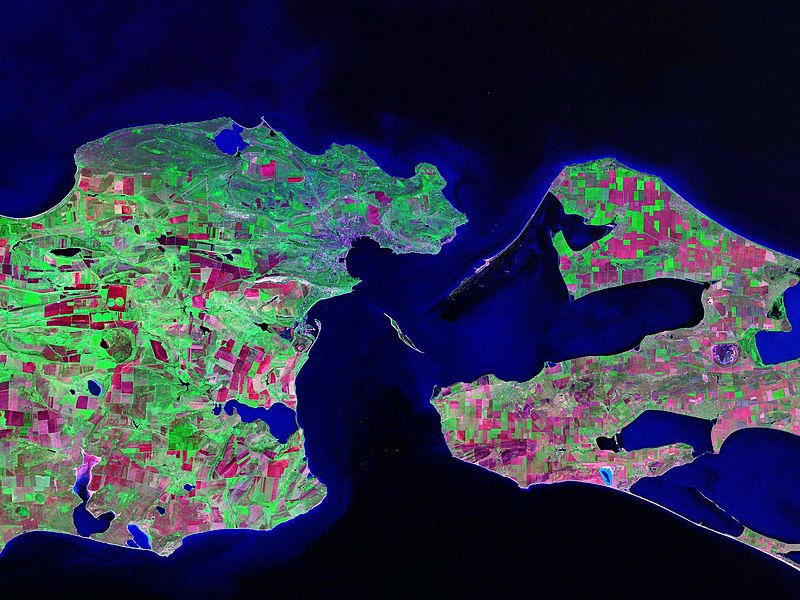
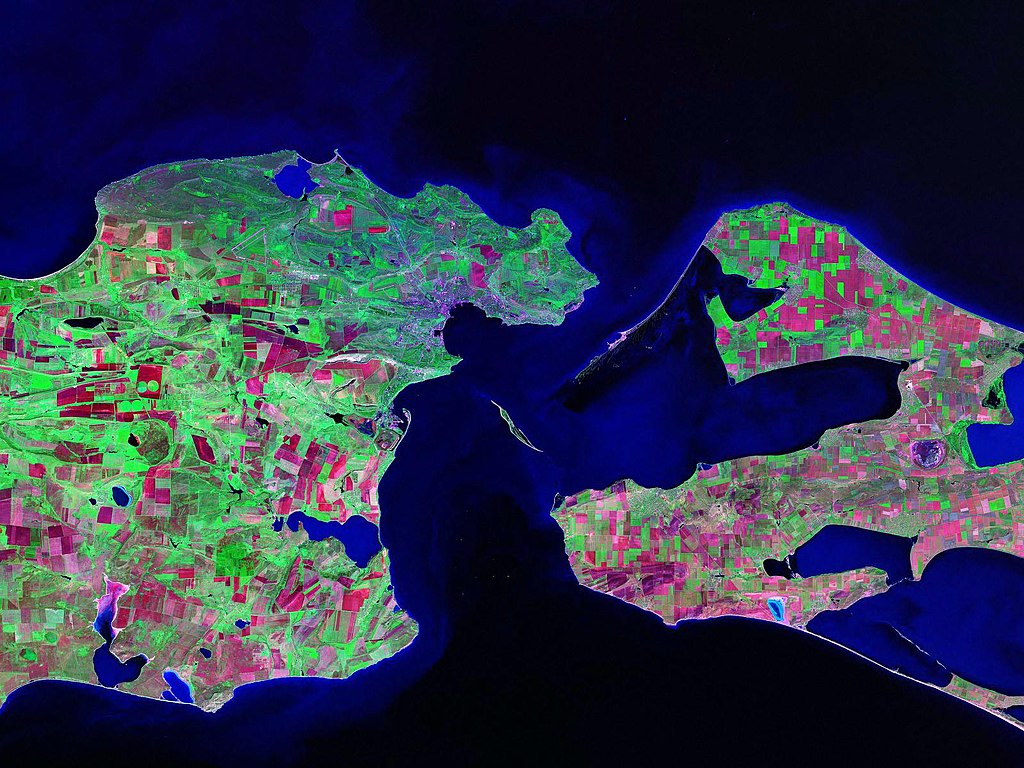
Landsat satellite (false color) photo of Kerch Strait between the Sea of Azov and the Black Sea.
Source: zulu.ssc.nasa.gov
| Camera location | | View this and other nearby images on: OpenStreetMap |
|---|
Litsenziyalama
| This file is in the public domain in the United States because it was solely created by NASA. NASA copyright policy states that "NASA material is not protected by copyright unless noted". (See Template:PD-USGov, NASA copyright policy page or JPL Image Use Policy.) | ||
 |
Warnings:
|
Faylnıñ keçmişi
Faylnıñ kerekli anki alını körmek içün tarihqa/saatqa basıñız.
| Tarih ve saat | Kiçik resim | En × boy | Qullanıcı | İzaat | |
|---|---|---|---|---|---|
| şimdiki | 13:52, 2006 s. oktâbrniñ 17 | | 1.600 × 1.200 (294 KB) | Balcer~commonswiki | Landsat satellite (false color) photo of Kerch Strait between the Sea of Azov and the Black Sea. Source:zulu.ssc.nasa.gov Category:Black Sea Category:Satellite pictures of Russia Category:Satellite pictures of Ukraine |
Fayl qullanıluvı
Bu saife qullana bu fayldı:
Umumiy fayl qullanıluvı
Bu vikilerde bu fayldı qullana:
- be.wikipedia.org qullanım
- ca.wikipedia.org qullanım
- ceb.wikipedia.org qullanım
- cs.wikipedia.org qullanım
- de.wikipedia.org qullanım
- el.wikipedia.org qullanım
- en.wikipedia.org qullanım
- eo.wikipedia.org qullanım
- es.wikipedia.org qullanım
- fa.wikipedia.org qullanım
- fi.wikipedia.org qullanım
- fr.wikipedia.org qullanım
- hr.wikipedia.org qullanım
- hy.wikipedia.org qullanım
- it.wikipedia.org qullanım
- ko.wikipedia.org qullanım
- nn.wikipedia.org qullanım
- no.wikipedia.org qullanım
- pl.wikipedia.org qullanım
- pnb.wikipedia.org qullanım
- pt.wikipedia.org qullanım
- ru.wikipedia.org qullanım
- sk.wikipedia.org qullanım
- sv.wikipedia.org qullanım
- tr.wikipedia.org qullanım
- ug.wikipedia.org qullanım
- uk.wikipedia.org qullanım
- Конфлікт щодо острова Тузла
- Керченська протока
- Користувач:Alex Blokha/Події в Вікіпедії/6 жовтня
- Користувач:Alex Blokha/Події в Вікіпедії/23 жовтня
- Користувач:Alex Blokha/Події в Вікіпедії/2 грудня
- Користувач:Alex Blokha/Події в Вікіпедії/7 січня
- Користувач:Alex Blokha/Події в Вікіпедії/19 лютого
- Державний кордон України
- Користувач:Alex Blokha/Дні згадані в Вікіпедії/Україна/6 жовтня
- Користувач:Alex Blokha/Дні згадані в Вікіпедії/Україна/22 жовтня
- Користувач:Alex Blokha/Дні згадані в Вікіпедії/Україна/2 грудня
- Користувач:Alex Blokha/Дні згадані в Вікіпедії/Україна/7 січня
- Президентство Леоніда Кучми
View more global usage of this file.