
Fayl:Isle of Man topographic map-ru.svg

Size of this PNG preview of this SVG file: 654 × 600 pixels. Başqa çözüm: 262 × 240 pixels | 524 × 480 pixels | 838 × 768 pixels | 1.117 × 1.024 pixels | 2.234 × 2.048 pixels | 1.200 × 1.100 pixels.
Kerçek fayl (SVG faylı, nominal 1.200 × 1.100 piksel, fayl büyükligi: 644 KB)
| Tasvir |
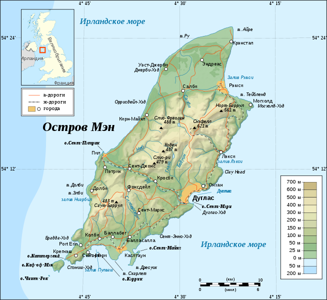
English: Topographic map in Russian of the Isle of Man.
Note : The shaded relief is a raster image embedded in the SVG. Français : Carte topographique en russe de l'Île de Man.
Note : Le relief ombré est une image bitmap embarquée dans le fichier SVG. Português: Mapa topográfico (em Russo) da Ilha de Man.
Русский: Топографическая карта острова Мэн на русском языке |
||||||||
| Tarih | |||||||||
| Menba |
Own work ; Topographic map : NASA Shuttle Radar Topography Mission (SRTM3 v.2) (public domain) edited with 3DEM from Visualization Software LLC and vectorized with Inkscape ; UTM projection ; WGS84 datum ; shaded relief (composite image of N-W, W and N lightning positions) ; Approximate scale of topographic data and shore / lakes limits : 1:372,000 ; Other references used for additional data : * Image:IsleofManmap.png modified by en-user:Kelisi under GFDL ; * Demis add-on for World Wind (see the approval e-mail and Demis forum) ; * NASA World Wind ; * UK Genealogy map ; * Microsoft Encarta atlas (1999 edition) ; * Locator map : Image:Gb4dot_merged_mapcolors.svg created by Wereon and Ilmari Karonen in public domain. |
||||||||
| Yaratıcı | Eric Gaba (Sting - fr:Sting, Pauk - Russian map) | ||||||||
| İzin (Faylnı yañıdan qullanuv) |
|
||||||||
| Other versions |
[]
|


Faylnıñ keçmişi
Faylnıñ kerekli anki alını körmek içün tarihqa/saatqa basıñız.
| Tarih ve saat | Kiçik resim | En × boy | Qullanıcı | İzaat | |
|---|---|---|---|---|---|
| şimdiki | 04:55, 2008 s. sentâbrniñ 29 | | 1.200 × 1.100 (644 KB) | Pauk | {{Information |Description={{en|Topographic map in English of the Isle of Man.<br/>''Note :'' The shaded relief is a raster image embedded in the SVG.}} {{fr|Carte topographique en anglais de l'Île de Man.<br/>''No |
Fayl qullanıluvı
Bu saife qullana bu fayldı:
Umumiy fayl qullanıluvı
Bu vikilerde bu fayldı qullana:
- ba.wikipedia.org qullanım
- cv.wikipedia.org qullanım
- hy.wikipedia.org qullanım
- lbe.wikipedia.org qullanım
- ru.wikipedia.org qullanım
- Остров Мэн
- Снейфелл
- Шаблон:ПозКарта Остров Мэн
- Шаблон:Potd/2008-11
- Проект:Тематическая неделя европейских регионов/Неделя острова Мэн
- Чикен-Рок
- Салби (река)
- Ду (приток Гласса)
- Каф-оф-Мэн
- Сент-Патрик (остров)
- Рамси (залив)
- Салби (водохранилище)
- Список населённых пунктов острова Мэн
- История острова Мэн
- Малл-Хилл
- Кронк-Самэрк
- ru.wikinews.org qullanım
- sah.wikipedia.org qullanım
- xal.wikipedia.org qullanım