
Fayl:Gais AR Dorfplatz Panorama 1.jpg
Size of this preview: 800 × 181 pixels. Başqa çözüm: 320 × 72 pixels | 640 × 145 pixels | 1.024 × 231 pixels | 1.280 × 289 pixels | 6.351 × 1.435 pixels.
Kerçek fayl (6.351 × 1.435 piksel, fayl büyükligi: 6,67 MB, MIME çeşiti: image/jpeg)
Faylğa ait qısqa tarif
| Tasvir |
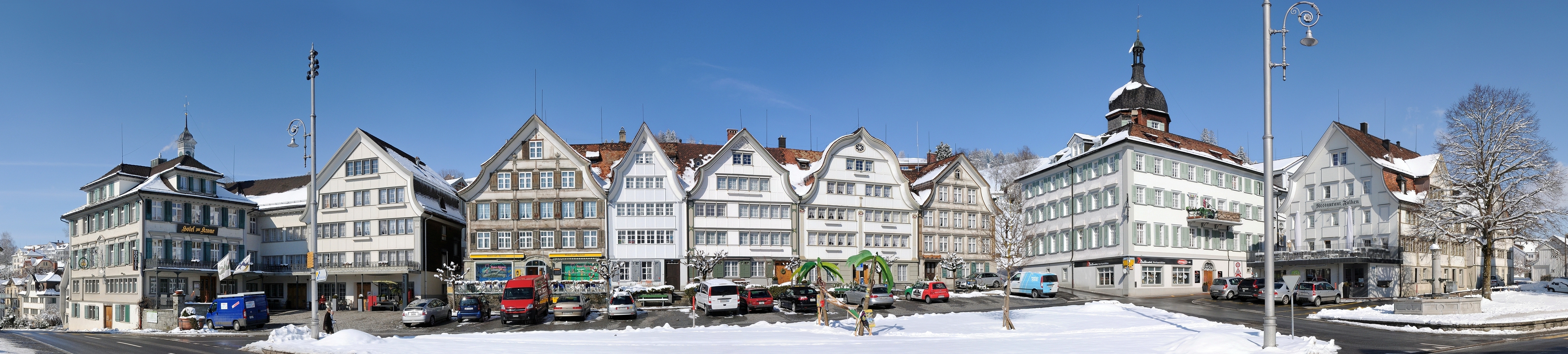
Deutsch: Panorama im Dorfzentrum von Gais. Gais ist eine politische Gemeinde im Mittelland des Kantons Appenzell Ausserrhoden in der Schweiz. Besonders hervorzuheben sind die unterschiedlichen Giebelvarianten. Français : Vue panoramique sur le centre-ville de Gais, une commune suisse du canton d'Appenzell Rhodes-Extérieures.
|
||
| Tarih | |||
| Menba | Öz işi | ||
| Yaratıcı | böhringer friedrich | ||
| İzin (Faylnı yañıdan qullanuv) |
I, the copyright holder of this work, hereby publish it under the following license: This file is licensed under the Creative Commons Attribution-Share Alike 2.5 Generic license.
|

| Camera location | | View this and other nearby images on: OpenStreetMap |
|---|
This Photo was taken by Böhringer Friedrich.
|
Feel free to use my photos, but please mention me as the author and if you want send me a message. or (rufre@lenz-nenning.at) |
Assessment
|
This image was selected as picture of the day on Wikimedia Commons for 26 August 2011. It was captioned as follows: Other languages:
Français : Gais est une commune suisse du canton d'Appenzell Rhodes-Extérieures. 日本語: スイス アッペンツェル・アウサーローデン準州のガイス村 |
This image has been assessed using the Quality image guidelines and is considered a Quality image.
|
Faylnıñ keçmişi
Faylnıñ kerekli anki alını körmek içün tarihqa/saatqa basıñız.
| Tarih ve saat | Kiçik resim | En × boy | Qullanıcı | İzaat | |
|---|---|---|---|---|---|
| şimdiki | 20:37, 2011 s. fevralniñ 23 | 6.351 × 1.435 (6,67 MB) | Böhringer | {{Information |Description= {{de| Panorama im Dorfzentrum von Gais.}} |Source= {{Own}} |Date= 2011-02-23 |Author= böhringer friedrich |Permission={{self|cc-by-sa-2.5}} |other_versions= }} {{User:Böhringer/Template:Cre |
Fayl qullanıluvı
Bu saife qullana bu fayldı:
Umumiy fayl qullanıluvı
Bu vikilerde bu fayldı qullana:
- ba.wikipedia.org qullanım
- be-tarask.wikipedia.org qullanım
- bn.wikipedia.org qullanım
- cv.wikipedia.org qullanım
- de.wikipedia.org qullanım
- hu.wikipedia.org qullanım
- kk.wikipedia.org qullanım
- ko.wikipedia.org qullanım
- krc.wikipedia.org qullanım
- lbe.wikipedia.org qullanım
- mg.wikipedia.org qullanım
- os.wikipedia.org qullanım
- pl.wikipedia.org qullanım
- ru.wikipedia.org qullanım
- ru.wikinews.org qullanım
- sah.wikipedia.org qullanım
- uk.wikipedia.org qullanım
- vi.wikipedia.org qullanım
- xal.wikipedia.org qullanım
- zh.wikipedia.org qullanım