
Fayl:Crazywell cross 1.JPG

Size of this preview: 800 × 600 pixels. Başqa çözüm: 320 × 240 pixels | 640 × 480 pixels | 1.024 × 768 pixels | 1.280 × 960 pixels | 2.048 × 1.536 pixels.
Kerçek fayl (2.048 × 1.536 piksel, fayl büyükligi: 1,42 MB, MIME çeşiti: image/jpeg)
|

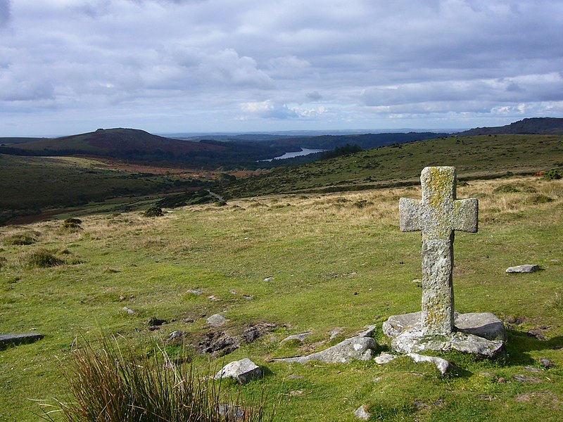
This image was selected as picture of the day on Wikimedia Commons for 8 June 2009. It was captioned as follows: English: Ancient cross close to Crazywell Pool on southern Dartmoor. Other languages:
Bahasa Indonesia: Salib tua di dekat kolam Crazywell di Dartmoor selatan, Inggris. Dansk: Gammelt kors nær Crazywell Pool i den sydlige del af Dartmoor nationalpark i Storbritannien. Deutsch: Steinkreuz im Dartmoor, Südwestengland English: Ancient cross close to Crazywell Pool on southern Dartmoor. Español: Cruz antigua cerca de Crazywell Pool, al sur de Dartmoor. Esperanto: antikva ŝtona kruco proksime al la lageto Crazywell Pool en la nacia parko Dartmoor en Britio Français : Ancienne croix près de l'étang de Crazywell, dans le sud du parc naturel du Dartmoor. Elle était vraisemblablement utilisée comme marque de balisage pour le chemin allant du monastère de Buckfast au monastère de Tavistock. Nederlands: oud kruis nabij de Crazywell Pool in het zuiden van de Dartmoor in het Engelse graafschap Devon Polski: Starodawny krzyż w pobliżu Crazywell Pool, na południe od Parku Narodowego Dartmoor Română: Cruce veche, lângă Crazywell Pool, în sudul Dartmoorului. Македонски: Древен крст близу Крејзивел Пул во јужен Дартмур. 한국어: 남부 다트무어 Crazywell Pool 가까운 곳에 위치한 고대 십자가 中文: 达特穆尔南部疯狂井池古老的十字架。 中文(繁體): 達特穆爾南部瘋狂井池古老的十字架。 |

|
This image has been assessed under the valued image criteria and is considered the most valued image on Commons within the scope: Dartmoor Crosses. You can see its nomination here. |
Faylğa ait qısqa tarif
| Tasvir |
English: Ancient cross close to Crazywell Pool on southern Dartmoor. It may well have been used as a marker for the track from the monastery at Buckfast to the monastery at Tavistock. Burrator reservoir can be seen in the distance.
Français : Ancienne croix près de l'étang de Crazywell, dans le sud du parc naturel du Dartmoor. Elle était vraisemblablement utilisée comme marque de balisage pour le chemin allant du monastère de Buckfast au monastère de Tavistock. Le lac réservoir de Burrator est visible à l'arrière-plan
Deutsch: Historisches Kreuz in der Nähe von Crazywell Pool im südlichen Dartmoor (Devon, UK). Möglicherweise wurde es als Wegweiser vom Kloster in Buckfast zum Kloster von Tavistock genutzt. Im Hintergrund ist das Wasserreservoir von Burrator zu erkennen. |
| Tarih | 29 sentâbr 2008 (created) |
| Menba | Öz işi |
| Yaratıcı | Myself – Herby talk thyme |
| Camera location | | View this and other nearby images on: OpenStreetMap |
|---|
Litsenziyalama
I, the copyright holder of this work, hereby publish it under the following licenses:

|
Permission is granted to copy, distribute and/or modify this document under the terms of the GNU Free Documentation License, Version 1.2 or any later version published by the Free Software Foundation; with no Invariant Sections, no Front-Cover Texts, and no Back-Cover Texts. A copy of the license is included in the section entitled GNU Free Documentation License. |
This file is licensed under the Creative Commons Attribution-Share Alike 4.0 International, 3.0 Unported, 2.5 Generic, 2.0 Generic and 1.0 Generic license.
- Azatsıñız:
- paylaşuv – qopyaluv, dağıtuv ve iletüv
- remiks etüv – uyğunlaştıruv
- Bu şartlar astında:
- attribution – You must give appropriate credit, provide a link to the license, and indicate if changes were made. You may do so in any reasonable manner, but not in any way that suggests the licensor endorses you or your use.
- aynı şekilde paylaşuv – If you remix, transform, or build upon the material, you must distribute your contributions under the same or compatible license as the original.
İstedigiñiz lisansnı seçebilirsiñiz.
Faylnıñ keçmişi
Faylnıñ kerekli anki alını körmek içün tarihqa/saatqa basıñız.
| Tarih ve saat | Kiçik resim | En × boy | Qullanıcı | İzaat | |
|---|---|---|---|---|---|
| şimdiki | 10:05, 2008 s. oktâbrniñ 1 | | 2.048 × 1.536 (1,42 MB) | Herbythyme | {{Information| |Description = Ancient cross close to Crazywell Pool on southern Dartmoor. It may well have been used as a marker for the track from the monastery at Buckfast to the monastery at Tavistock. |Source = self-made |Date = c |
Fayl qullanıluvı
Bu saife qullana bu fayldı:
Umumiy fayl qullanıluvı
Bu vikilerde bu fayldı qullana:
- bg.wikipedia.org qullanım
- bn.wikipedia.org qullanım
- cv.wikipedia.org qullanım
- en.wikipedia.org qullanım
- Dartmoor
- South West England
- Crazywell Pool
- Wikipedia:WikiProject UK geography
- Wikipedia:Featured pictures/Places/Landscapes
- Wikipedia:Featured pictures thumbs/15
- User talk:Herbythyme/Arc4
- Wikipedia:Featured picture candidates/Crazywell Cross
- Dartmoor crosses
- Wikipedia:Featured picture candidates/February-2009
- Wikipedia:Wikipedia Signpost/2009-02-08/Features and admins
- Portal:England/Selected picture/04 2009
- User talk:Herbythyme/Arc5
- Wikipedia:Picture of the day/November 2009
- Template:POTD/2009-11-15
- Wikipedia:Did you know/Statistics/Monthly DYK pageview leaders/2009
- Wikipedia:Recent additions/2009/February
- User talk:Mbz1/Archive1
- Wikipedia:WikiProject Devon/Featured content
- Wikipedia:Wikipedia Signpost/2009-02-08/SPV
- Wikipedia:WikiProject England/The West Country Challenge
- Wikipedia:WikiProject England/The West Country Challenge/Devon
- User:Trans-Neptunian object
- Wikipedia:Wikipedia Signpost/Single/2009-02-08
- fi.wikipedia.org qullanım
- fr.wikipedia.org qullanım
- he.wikipedia.org qullanım
- hu.wikipedia.org qullanım
- it.wikipedia.org qullanım
- ko.wikipedia.org qullanım
- lbe.wikipedia.org qullanım
- lt.wikipedia.org qullanım
- lv.wikipedia.org qullanım
- mk.wikipedia.org qullanım
- ml.wikipedia.org qullanım
- nl.wikipedia.org qullanım
- os.wikipedia.org qullanım
- pl.wikipedia.org qullanım
- pl.wikivoyage.org qullanım
View more global usage of this file.