
Fayl:Abbasid Caliphate most extant.png
Daa yüksek ayırımlılıqqa saip versiya yoq.
Abbasid_Caliphate_most_extant.png (800 × 487 piksel, fayl büyükligi: 85 KB, MIME çeşiti: image/png)
| Tasvir |
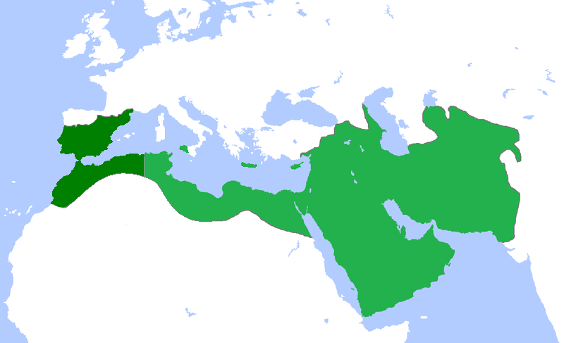
English: Locator map for the Abbasid Caliphate at its greatest extent, before the independence of al-Maghrib (Morocco and parts of Algeria) in 744 as well as al-Andalus (Spain and Portugal) 7yghfjs560the in the early 333 |
| Tarih | (UTC) |
| Menba | |
| Yaratıcı |
|
| This is a retouched picture, which means that it has been digitally altered from its original version. Modifications: seperated the parts that gained independance from the Abbasid Caliphate. The original can be viewed here: Umayyad750ADloc.png:
|
I, the copyright holder of this work, hereby publish it under the following license:
This file is licensed under the Creative Commons Attribution 3.0 Unported license.
- Azatsıñız:
- paylaşuv – qopyaluv, dağıtuv ve iletüv
- remiks etüv – uyğunlaştıruv
- Bu şartlar astında:
- attribution – You must give appropriate credit, provide a link to the license, and indicate if changes were made. You may do so in any reasonable manner, but not in any way that suggests the licensor endorses you or your use.
Original upload log
This image is a derivative work of the following images:
- File:Umayyad750ADloc.png licensed with Cc-by-3.0
- 2009-04-22T16:17:51Z Gabagool 1481x902 (51495 Bytes) some corrections..
- 2009-04-20T16:10:54Z Gabagool 1481x902 (51573 Bytes) {{Information |Description={{en|1=Locator map for the Umayyad Caliphate at its greatest extent, c. AD 750. (Partially based on ''Atlas of World History'' (2007) - World 500-750, map.)}} |Source=Own work by uploader |Author=[
Uploaded with derivativeFX
Faylnıñ keçmişi
Faylnıñ kerekli anki alını körmek içün tarihqa/saatqa basıñız.
| Tarih ve saat | Kiçik resim | En × boy | Qullanıcı | İzaat | |
|---|---|---|---|---|---|
| şimdiki | 18:50, 2013 s. aprelniñ 13 | | 800 × 487 (85 KB) | Fry1989 | vandalism |
| 16:01, 2013 s. aprelniñ 13 |  | 800 × 487 (87 KB) | Mouh2jijel | Reverted to version as of 08:30, 13 April 2013 | |
| 14:32, 2013 s. aprelniñ 13 |  | 800 × 487 (85 KB) | Omar-toons | Reverted to version as of 23:40, 15 November 2012 rv unjustified revert | |
| 08:30, 2013 s. aprelniñ 13 |  | 800 × 487 (87 KB) | Mouh2jijel | Reverted to version as of 18:50, 8 April 2013 | |
| 06:18, 2013 s. aprelniñ 13 |  | 800 × 487 (85 KB) | Omar-toons | Reverted to version as of 23:40, 15 November 2012 unjustified revert | |
| 18:50, 2013 s. aprelniñ 8 |  | 800 × 487 (87 KB) | Mouh2jijel | Reverted to version as of 17:29, 24 April 2012 | |
| 23:40, 2012 s. noyabrniñ 15 |  | 800 × 487 (85 KB) | Omar-toons | moving southern Ifriqiyan limits a little bit to the north | |
| 17:29, 2012 s. aprelniñ 24 |  | 800 × 487 (87 KB) | Cplakidas | corrections: Sardinia and Corsica were never taken, and Sicily was not completely conquered until the 870s | |
| 19:11, 2011 s. aprelniñ 25 |  | 800 × 487 (87 KB) | باسم | added a few Mediterranean islands | |
| 18:12, 2011 s. aprelniñ 25 |  | 800 × 487 (87 KB) | باسم | {{Information |Description={{en|1=Locator map for the Abbasid Caliphate at its greatest extent, before the independence of al maghrib (morocco and parts of algeria) as well as al andalus (Spain and Portugal)}} |Source=*File:Umayyad750ADloc.png |Date |
Fayl qullanıluvı
Bu saife qullana bu fayldı:
Umumiy fayl qullanıluvı
Bu vikilerde bu fayldı qullana:
- ar.wikipedia.org qullanım
- العراق
- بغداد
- تاريخ العراق
- البصرة
- تاريخ إسلامي
- خلافة إسلامية
- الدولة العباسية
- غامد
- برامكة
- قائمة الخلفاء
- بوابة:الإسلام/مقالة مختارة
- تاريخ اليمن الإسلامي
- بوابة:الإمبراطورية الروسية
- بوابة:الإمبراطورية الروسية/بوابات شقيقة
- ويكيبيديا:مقالة الصفحة الرئيسية المختارة/152
- خالد بن برمك
- الممالك في إفريقيا قبل الاستعمار
- يحيى البرمكي
- بوابة:مكة/مقالة مختارة/أرشيف
- بوابة:مكة/مقالة مختارة/10
- بوابة:الأديان/تاريخ ديني
- بوابة:الإسلام/دولة مختارة
- بوابة:الإسلام/دولة مختارة/3
- بوابة:العراق/مقالة مختارة/أرشيف
- بوابة:العراق/مقالة مختارة/2
- بوابة:التاريخ الإسلامي/مقالة مختارة/أرشيف
- مستخدم:باحث
- بوابة:التاريخ/فقرات منوعة/3
- بوابة:التاريخ/فقرات منوعة/أرشيف
- بوابة:التاريخ الإسلامي/دولة مختارة/أرشيف
- بوابة:الإمبراطورية الألمانية
- بوابة:الإمبراطورية الألمانية/بوابات شقيقة
- بوابة:إمبراطورية اليابان
- بوابة:إمبراطورية اليابان/بوابات شقيقة
- بوابة:الخلافة الراشدة
- بوابة:الدولة الأموية
- ويكيبيديا:قائمة اليوم المختارة/يوليو 2015
- بوابة:التاريخ الإسلامي/دولة مختارة/4
- قالب:قائمة اليوم المختارة/2015-07-04
- بوابة:الإمبراطورية الفرنسية الأولى/بوابات شقيقة
- بوابة:الإمبراطورية الفرنسية الأولى
- بوابة:الإمبراطورية النمساوية/بوابات شقيقة
- بوابة:الإمبراطورية النمساوية
- بوابة:العالم الإسلامي
- قالب:مواضيع متعلقة 3
- قالب:مواضيع متعلقة 3/شرح
- بوابة:العالم الإسلامي/تاريخ
- بوابة:العالم الإسلامي/مواضيع متعلقة
- بوابة:الدولة العباسية/واجهة
- بوابة:الدولة العباسية
View more global usage of this file.