
Fayl:Vatican City map EN.png

Size of this preview: 777 × 600 pixels. Başqa çözüm: 311 × 240 pixels | 622 × 480 pixels | 995 × 768 pixels | 1.280 × 988 pixels | 2.560 × 1.977 pixels | 2.888 × 2.230 pixels.
Kerçek fayl (2.888 × 2.230 piksel, fayl büyükligi: 2,41 MB, MIME çeşiti: image/png)
Faylğa ait qısqa tarif
| Description |
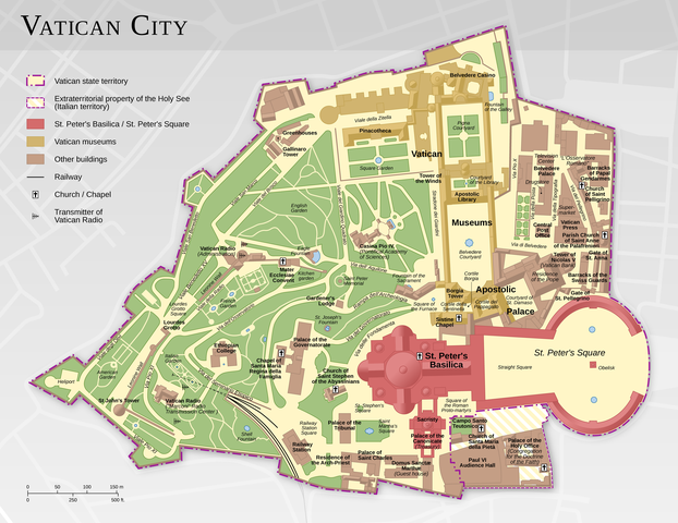
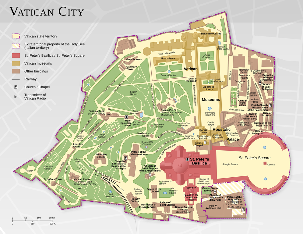
Deutsch: Karte der Vatikanstadt (englische Version)
English: Map of the Vatican City (English version)
Español: Mapa de la Ciudad del Vaticano (versión en inglés).
Suomi: Vatikaanin kartta (englanninkielinen versio)
Français : Carte de la Cité du Vatican, à partir d'informations d'OpenStreetMap. Version en anglais ; voir la version en français ici : Vatican City map FR.png
中文:梵蒂冈城国地图(英语版本)
Bosanski: Karta Vatikana - sadrži kartografske podatke sa projekta ©OpenStreetMap (ODbL).
|
|||||||||
| Tarih | ||||||||||
| Menba |
Öz işi |
|||||||||
| Creator | ||||||||||
| İzin (Faylnı yañıdan qullanuv) |
|
|||||||||
| Geotemporal data | ||||||||||
| Bounding box |
|
|||||||||
| Georeferencing | ||||||||||
| Other versions |
|
|||||||||


|
This map has been made or improved in the German Kartenwerkstatt (Map Lab). You can propose maps to improve as well.
|
Litsenziyalama
This file is licensed under the Creative Commons Attribution-Share Alike 3.0 Unported license.
Attribution: Thomas Römer/OpenStreetMap data
- Azatsıñız:
- paylaşuv – qopyaluv, dağıtuv ve iletüv
- remiks etüv – uyğunlaştıruv
- Bu şartlar astında:
- attribution – You must give appropriate credit, provide a link to the license, and indicate if changes were made. You may do so in any reasonable manner, but not in any way that suggests the licensor endorses you or your use.
- aynı şekilde paylaşuv – If you remix, transform, or build upon the material, you must distribute your contributions under the same or compatible license as the original.
Assessment
|

This image was selected as picture of the day on Wikimedia Commons for 11 February 2015. It was captioned as follows: Other languages:
Bosanski: Karta Vatikana - sadrži kartografske podatke sa projekta ©OpenStreetMap (ODbL). |
Faylnıñ keçmişi
Faylnıñ kerekli anki alını körmek içün tarihqa/saatqa basıñız.
| Tarih ve saat | Kiçik resim | En × boy | Qullanıcı | İzaat | |
|---|---|---|---|---|---|
| şimdiki | 11:44, 2021 s. fevralniñ 12 | | 2.888 × 2.230 (2,41 MB) | Foghe | St. Damasco → St. Damaso. |
| 09:22, 2013 s. aprelniñ 11 |  | 2.888 × 2.230 (2,14 MB) | Thoroe | larger render | |
| 17:12, 2013 s. aprelniñ 10 |  | 1.733 × 1.338 (1,11 MB) | Thoroe | small fixes | |
| 15:59, 2013 s. martnıñ 23 |  | 1.733 × 1.338 (1,1 MB) | Thoroe | minor fixes | |
| 00:41, 2013 s. martnıñ 23 |  | 1.733 × 1.338 (1,09 MB) | Thoroe | {{Information |Description ={{en|1=Map of the Vatican City (English version)}} {{de|1=Karte der Vatikanstadt (englische Version)}} |Source ={{own}} *[http://www.vatican.va/news_services/press/docume... |
Fayl qullanıluvı
Bu saife qullana bu fayldı:
Umumiy fayl qullanıluvı
Bu vikilerde bu fayldı qullana:
- af.wikipedia.org qullanım
- be-tarask.wikipedia.org qullanım
- ca.wikipedia.org qullanım
- cv.wikipedia.org qullanım
- de.wikipedia.org qullanım
- en.wikipedia.org qullanım
- Wikipedia:Featured pictures/Diagrams, drawings, and maps/Maps
- Talk:Vatican City/Archive 1
- User talk:Thoroe
- Wikipedia:Featured pictures thumbs/37
- User talk:Crisco 1492/Archive 44
- Wikipedia:Featured picture candidates/Vatican City map
- Wikipedia:Featured picture candidates/October-2013
- Wikipedia:Picture of the day/August 2015
- Template:POTD/2015-08-07
- Wikipedia:Main Page history/2015 August 7
- User:John Paul II/Line of Popes
- Portal:Geography/Selected picture
- User:ਕਰਨ 13/sandbox
- en.wikivoyage.org qullanım
- fo.wikipedia.org qullanım
- fr.wikipedia.org qullanım
- hu.wikipedia.org qullanım
- ka.wikipedia.org qullanım
- ko.wikipedia.org qullanım
- krc.wikipedia.org qullanım
- lbe.wikipedia.org qullanım
- www.mediawiki.org qullanım
- mg.wikipedia.org qullanım
- os.wikipedia.org qullanım
- pl.wikipedia.org qullanım
- pt.wikipedia.org qullanım
- ru.wikipedia.org qullanım
- ru.wikinews.org qullanım
- sah.wikipedia.org qullanım
- sv.wikipedia.org qullanım
- tr.wikipedia.org qullanım
- tt.wikipedia.org qullanım
- uk.wikipedia.org qullanım
View more global usage of this file.