
Fayl:Hochtor from Hesshütte, Ennstal Alps, Austria.jpg

Size of this preview: 800 × 272 pixels. Başqa çözüm: 320 × 109 pixels | 640 × 217 pixels | 1.024 × 348 pixels | 1.280 × 435 pixels | 2.560 × 869 pixels | 13.340 × 4.530 pixels.
Kerçek fayl (13.340 × 4.530 piksel, fayl büyükligi: 61,45 MB, MIME çeşiti: image/jpeg)
| Warning | The original file is very high-resolution. It might not load properly or could cause your browser to freeze when opened at full size. |
|---|
Faylğa ait qısqa tarif
| Tasvir |
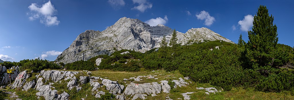
Français : Vue panoramique du mont Hochtor (2.369 m) depuis le refuge Hesshütte. Parc national de Gesäuse, Alpes d'Ennstal, Autriche
Polski: Panorama szczytu Hochtor (2369 m n.p.m.) widziana ze schroniska Hesshütte w Parku Narodowym Gesäuse w Alpach Ennstalskich, w Austrii.
Español: Vista del Hochtor (2369 m) desde Hesshütte. Parque nacional Gesäuse, Alpes de Ennstal, Austria.
Italiano: Il monte Hochtor (2 369 m s.l.m.) visto dal rifugio Hesshütte, presso il parco nazionale Gesäuse in Austria, sulle Alpi dell'Ennstal
Nederlands: De Hochtor in het Nationaal Park Gesäuse is met 2369 meter de hoogste berg van de Ennstaler Alpen in de Oostenrijkse deelstaat Stiermarken
Português: Montanha Hochtor (2369 m) vista do Hesshütte, Parque nacional Gesäuse, Alpes de Ennstal, Áustria. |
| Tarih | |
| Menba | Öz işi |
| Yaratıcı | Michal Klajban |
| Object location | | View this and other nearby images on: OpenStreetMap |
|---|
| Camera location | | View this and other nearby images on: OpenStreetMap |
|---|

|
NOTE: This image is a panorama of Hochtor consisting of 7 frames that were merged or stitched in PtGui & Lightroom. As a result, this image necessarily underwent some form of digital manipulation. These manipulations may include blending, blurring, cloning, and colour and perspective adjustments. As a result of these adjustments, the image content may be slightly different from reality at the points where multiple images were combined. This manipulation is often required due to lens, perspective, and parallax distortions.
|
The production, editing or release of this file was supported by the Community-Budget of Wikimedia Deutschland. To see other files made with the support of Wikimedia Deutschland, please see the category Supported by Wikimedia Deutschland. |
Assessment
|
This image was selected as picture of the day on Wikimedia Commons for 23 June 2019. It was captioned as follows: Other languages:
Español: Vista del Hochtor (2369 m) desde Hesshütte. Parque nacional Gesäuse, Alpes de Ennstal, Austria. Français : Vue panoramique du mont Hochtor (2.369 m) depuis le refuge Hesshütte. Parc national de Gesäuse, Alpes d'Ennstal, Autriche. Italiano: Il monte Hochtor (2 369 m s.l.m.) visto dal rifugio Hesshütte, presso il parco nazionale Gesäuse in Austria, sulle Alpi dell'Ennstal Nederlands: De Hochtor in het Nationaal Park Gesäuse is met 2369 meter de hoogste berg van de Ennstaler Alpen in de Oostenrijkse deelstaat Stiermarken Polski: Panorama szczytu Hochtor (2369 m n.p.m.) widziana ze schroniska Hesshütte w Parku Narodowym Gesäuse w Alpach Ennstalskich, w Austrii. Português: Montanha Hochtor (2369 m) vista do Hesshütte, Parque nacional Gesäuse, Alpes de Ennstal, Áustria. |
Litsenziyalama
I, the copyright holder of this work, hereby publish it under the following license:
This file is licensed under the Creative Commons Attribution-Share Alike 4.0 International license.
- Azatsıñız:
- paylaşuv – qopyaluv, dağıtuv ve iletüv
- remiks etüv – uyğunlaştıruv
- Bu şartlar astında:
- attribution – You must give appropriate credit, provide a link to the license, and indicate if changes were made. You may do so in any reasonable manner, but not in any way that suggests the licensor endorses you or your use.
- aynı şekilde paylaşuv – If you remix, transform, or build upon the material, you must distribute your contributions under the same or compatible license as the original.
Faylnıñ keçmişi
Faylnıñ kerekli anki alını körmek içün tarihqa/saatqa basıñız.
| Tarih ve saat | Kiçik resim | En × boy | Qullanıcı | İzaat | |
|---|---|---|---|---|---|
| şimdiki | 19:15, 2018 s. sentâbrniñ 11 | 13.340 × 4.530 (61,45 MB) | Podzemnik | fix a small issue | |
| 13:50, 2018 s. sentâbrniñ 10 | 13.340 × 4.530 (61,45 MB) | Podzemnik | some spots removed | ||
| 13:38, 2018 s. sentâbrniñ 10 | 13.340 × 4.530 (61,47 MB) | Podzemnik | User created page with UploadWizard |
Fayl qullanıluvı
Bu saife qullana bu fayldı:
Umumiy fayl qullanıluvı
Bu vikilerde bu fayldı qullana:
- af.wikipedia.org qullanım
- be-tarask.wikipedia.org qullanım
- bn.wikipedia.org qullanım
- cv.wikipedia.org qullanım
- fr.wikipedia.org qullanım
- hu.wikipedia.org qullanım
- hy.wikipedia.org qullanım
- it.wiktionary.org qullanım
- ka.wikipedia.org qullanım
- ko.wikipedia.org qullanım
- lbe.wikipedia.org qullanım
- lez.wikipedia.org qullanım
- mk.wikipedia.org qullanım
- os.wikipedia.org qullanım
- pt.wikipedia.org qullanım
- ru.wikipedia.org qullanım
- ru.wikinews.org qullanım
- sah.wikipedia.org qullanım
- sq.wikipedia.org qullanım
- tt.wikipedia.org qullanım
- uk.wikipedia.org qullanım
- vep.wikipedia.org qullanım
- zh.wikipedia.org qullanım