
Fayl:Gletsjerpad naar de Morteratschgletsjer 12-09-2019. (d.j.b) 01.jpg

Size of this preview: 800 × 533 pixels. Başqa çözüm: 320 × 213 pixels | 640 × 427 pixels | 1.024 × 683 pixels | 1.280 × 853 pixels | 2.560 × 1.707 pixels | 5.137 × 3.425 pixels.
Kerçek fayl (5.137 × 3.425 piksel, fayl büyükligi: 11,86 MB, MIME çeşiti: image/jpeg)
Faylğa ait qısqa tarif
| Tasvir |
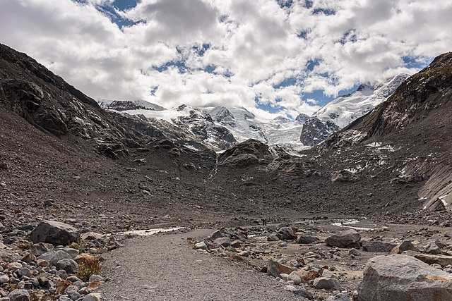
Nederlands: Bergpad naar de tong van de Morteratschgletsjer. Zicht op de imponerende Morteratschgletsjer. Gletsjerpad naar de Morteratschgletsjer. Wandeltochten vanuit Val Sinestra (1474 meter), in het Unterengadin in nl:Graubünden, Zwitserland
English: Mountain path to the tongue of the Morteratsch glacier. View of the impressive Morteratsch glacier. Walking tours from Val Sinestra (1474 meters), in Unterengadin in Graubünden, Switzerland
Українська: Гірська стежка до язика льодовика Мортерач і вид на сам льодовик.
Français : Sentier en montagne menant au glacier Morteratsch (Suisse).
Magyar: Hegyi út a Morteratsch-gleccser nyelvéig háttérben a gleccserrel (Svájc)
Bosanski: Planinski put do jezika lednika Morteratsch.
العربية: الطريق الجبلي لسلسلة جبال مورتراتش الجليدية
Эрзянь: Мортерач эйпандонтень яннесь. |
| Tarih | |
| Menba | Öz işi |
| Yaratıcı | Dominicus Johannes Bergsma |
| Other versions |
|
_02.jpg)
_03.jpg)
_04.jpg)
_05.jpg)
_06.jpg)
_07.jpg)
_08.jpg)
| Camera location | | View this and other nearby images on: OpenStreetMap |
|---|
Litsenziyalama
I, the copyright holder of this work, hereby publish it under the following license:
This file is licensed under the Creative Commons Attribution-Share Alike 4.0 International license.
- Azatsıñız:
- paylaşuv – qopyaluv, dağıtuv ve iletüv
- remiks etüv – uyğunlaştıruv
- Bu şartlar astında:
- attribution – You must give appropriate credit, provide a link to the license, and indicate if changes were made. You may do so in any reasonable manner, but not in any way that suggests the licensor endorses you or your use.
- aynı şekilde paylaşuv – If you remix, transform, or build upon the material, you must distribute your contributions under the same or compatible license as the original.
Assessment
|

_01.jpg)
_01.jpg¶ms=046.427127_N_0009.933037_E_globe:Earth_type:camera__&language=crh)
_01.jpg)
_01.jpg)
This image was selected as picture of the day on Wikimedia Commons for 14 April 2021. It was captioned as follows: English: Mountain path to the tongue of the Morteratsch glacier. Other languages:
Bosanski: Planinski put do jezika lednika Morteratsch. English: Mountain path to the tongue of the Morteratsch glacier. Français : Sentier en montagne menant au glacier Morteratsch (Suisse). Magyar: Hegyi út a Morteratsch-gleccser nyelvéig háttérben a gleccserrel (Svájc) Українська: Гірська стежка до язика льодовика Мортерач і вид на сам льодовик. العربية : الطريق الجبلي لسلسلة جبال مورتراتش الجليدية |
Faylnıñ keçmişi
Faylnıñ kerekli anki alını körmek içün tarihqa/saatqa basıñız.
| Tarih ve saat | Kiçik resim | En × boy | Qullanıcı | İzaat | |
|---|---|---|---|---|---|
| şimdiki | 17:54, 2019 s. oktâbrniñ 20 | | 5.137 × 3.425 (11,86 MB) | Famberhorst | User created page with UploadWizard |
Fayl qullanıluvı
Bu saife qullana bu fayldı:
Umumiy fayl qullanıluvı
Bu vikilerde bu fayldı qullana:
- alt.wikipedia.org qullanım
- av.wikipedia.org qullanım
- be-tarask.wikipedia.org qullanım
- cv.wikipedia.org qullanım
- en.wikipedia.org qullanım
- hu.wikipedia.org qullanım
- hy.wikipedia.org qullanım
- it.wiktionary.org qullanım
- ka.wikipedia.org qullanım
- ko.wikipedia.org qullanım
- lbe.wikipedia.org qullanım
- lez.wikipedia.org qullanım
- mk.wikipedia.org qullanım
- os.wikipedia.org qullanım
- pt.wikipedia.org qullanım
- ru.wikipedia.org qullanım
- ru.wikinews.org qullanım
- sah.wikipedia.org qullanım
- sq.wikipedia.org qullanım
- uk.wikipedia.org qullanım
- vep.wikipedia.org qullanım
- www.wikidata.org qullanım
- zh.wikipedia.org qullanım
_01.jpg)