
Fayl:05june-dow7-wide.gif

Size of this preview: 800 × 478 pixels. Başqa çözüm: 320 × 191 pixels | 640 × 383 pixels | 1.024 × 612 pixels | 1.280 × 765 pixels | 1.828 × 1.093 pixels.
Kerçek fayl (1.828 × 1.093 piksel, fayl büyükligi: 32,26 MB, MIME çeşiti: image/gif, looped, 50 frames, 7,5san.)
Faylğa ait qısqa tarif
| Tasvir |
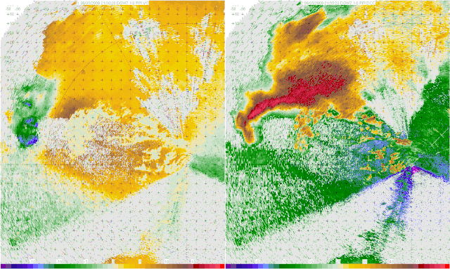
English: A Doppler on Wheels image of a tornadic thunderstorm near LaGrange, Wyoming (USA) captured during the VORTEX2 project. In the velocity image on the left, Blues/green represent winds moving towards the radar, and reds/yellows indicate winds moving away from the radar. The reason that some of the darker blues contain red/yellow within them is a trait known as Aliasing, where the winds are moving faster than the radar can detect. In the reflectivity image on the right, the main body of the storm can be seen, with the appendage on the bottom of the storm being a hook echo, which is associated directly with the tornado, and the tornado circulation itself can be seen as the doughnut like shape in the later part of the animation.
Español: Imagen radar de una tormenta de tornados cerca de La Grange (Wyoming), Estados Unidos, producida en el ambito del proyecto VORTEX2. La imagen de la izquierda representa la fuerza de los vientos, en azul los vientos que soplan hacia el radar, y en amarillo/rojo los que se alejan. Los puntos rojos sobre fondo azul son artefactos (aliasing) debidos a vientos que soplan a una velocidad superior al límite de detección del radar. La imagen de la derecha mide la reflectividad, y podemos ver la nube de tormenta principal, así como el eco en cadena del propio tornado. Al final de la animación, vemos el propio tornado, en forma de anillo marrón.
Français : Image Radar d'un orage à tornade près de La Grange, dans le Wyoming (États-Unis) prise dans le cadre du projet VORTEX2. L'image de gauche représente la puissance des vents, avec en bleu les vents soufflant vers le radar, et en jaune/rouge ceux qui s'éloignent. Les taches rouges sur fond bleu sont des artefacts (crénelage) dus à des vents soufflant à une vitesse supérieure à la limite de détection du radar. L'image de droite mesure la réflectivité, on peut y voir le nuage d'orage principal, ainsi que l'Écho en crochet du à la tornade elle-même. En fin d'animation, on voit la tornade elle-même, sous la forme d'un anneau brun.
Українська: Доплерівське зображення торнадної грози поблизу Ла-Грейндж, Вайомінг (США), зроблене під час проекту VORTEX2. На зображенні швидкості ліворуч блакитний/зелений означає вітер, що рухається в напрямку радара, а червоний/жовтий означає, що вітер рухається від радара. Причиною того, що деякі з темних синіх тонів містять червоний/жовтий колір, є особливість, відома як згладжування (аліасинг), коли вітер рухається швидше, ніж може виявити радар. На відбивному зображенні праворуч можна побачити основну частину шторму, при цьому відросток у нижній частині шторму є ехо-гачком, яка безпосередньо пов’язана з торнадо, а саму циркуляцію торнадо можна побачити як форму пончика в пізнішій частині анімації. |
|||||||||||||||||
| Tarih | ||||||||||||||||||
| Menba | http://vortex2.org/dowloops/ | |||||||||||||||||
| Yaratıcı |
|
|||||||||||||||||
| İzin (Faylnı yañıdan qullanuv) |
||||||||||||||||||
| Other versions | Derivative works of this file: 05june-dow7-wide2.ogv | |||||||||||||||||

| Object location | | View this and other nearby images on: OpenStreetMap |
|---|
Assessment
|

This image was selected as picture of the day on Wikimedia Commons for 5 June 2023. It was captioned as follows: English: A Doppler on Wheels image of a tornadic thunderstorm near La Grange, Wyoming (USA) captured during the VORTEX2 project. In the velocity image on the left, Blues/green represent winds moving towards the radar, and reds/yellows indicate winds moving away from the radar. The reason that some of the darker blues contain red/yellow within them is a trait known as Aliasing, where the winds are moving faster than the radar can detect. In the reflectivity image on the right, the main body of the storm can be seen, with the appendage on the bottom of the storm being a hook echo, which is associated directly with the tornado, and the tornado circulation itself can be seen as the doughnut like shape in the later part of the animation. Other languages:
Čeština: Dopplerův snímek tornádové bouře poblíž La Grange ve Wyomingu (USA), zachycený během projektu VORTEX2. Na obrázku rychlosti vlevo modrá/zelená představuje vítr pohybující se směrem k radaru a červená/žlutá označuje vítr pohybující se od radaru. Důvodem, proč některé tmavší modré barvy obsahují červenou/žlutou v sobě, je vlastnost známá jako aliasing, kdy se vítr pohybuje rychleji, než dokáže zachytit radar. Na reflexním snímku vpravo je vidět hlavní část bouře, přičemž přídavek na spodní straně bouře je hákovou ozvěnou, která je přímo spojena s tornádem, a samotnou cirkulaci tornáda lze vidět jako donut jako tvar v pozdější části animace. Deutsch: Aufnahme eines Tornados in der Nähe von LaGrange, Wyoming durch das VORTEX2-Projekt mit Hilfe eines mobilen Wetterradars (Doppler on Wheels). Im linken Bild steht blau/grün für Winde, die sich auf das Radar zubewegen, und rot/gelb für Winde, die sich vom Radar entfernen. Da sich einige der Winde schneller bewegen, als das Radar sie erfassen kann, erscheint rot und gelb im Bereich der dunkleren Blautöne (Alias-Effekt). Im rechten Reflektivitätsbild ist der Hauptkörper des Sturms zu sehen, wobei das Anhängsel am unteren Ende des Sturms ein Hakenecho ist, das in direktem Zusammenhang mit dem Tornado steht. Die Tornadozirkulation selbst ist im späteren Teil der Animation in Form eines Torus zu erkennen. English: A Doppler on Wheels image of a tornadic thunderstorm near La Grange, Wyoming (USA) captured during the VORTEX2 project. In the velocity image on the left, Blues/green represent winds moving towards the radar, and reds/yellows indicate winds moving away from the radar. The reason that some of the darker blues contain red/yellow within them is a trait known as Aliasing, where the winds are moving faster than the radar can detect. In the reflectivity image on the right, the main body of the storm can be seen, with the appendage on the bottom of the storm being a hook echo, which is associated directly with the tornado, and the tornado circulation itself can be seen as the doughnut like shape in the later part of the animation. Español: Imagen radar de una tormenta de tornados cerca de La Grange (Wyoming), Estados Unidos, producida en el ambito del proyecto VORTEX2. La imagen de la izquierda representa la fuerza de los vientos, en azul los vientos que soplan hacia el radar, y en amarillo/rojo los que se alejan. Los puntos rojos sobre fondo azul son artefactos (aliasing) debidos a vientos que soplan a una velocidad superior al límite de detección del radar. La imagen de la derecha mide la reflectividad, y podemos ver la nube de tormenta principal, así como el eco en cadena del propio tornado. Al final de la animación, vemos el propio tornado, en forma de anillo marrón. Français : Images d'une tempête accompagnée d'une tornade enregistrées par radar Doppler on Wheels dans le Wyoming (États-Unis). Italiano: Immagine radar di un tornado vicino a La Grange, Wyoming (USA) registrata durante il progetto VORTEX2 da un particolare radar meteorologico doppler montato su un mezzo a quattro ruote. Nell'immagine delle velocità a sinistra, i venti che si muovono verso il radar sono mostrati in blu/verde, mentre quelli che si muovono in senso opposto sono rappresentati in rosso/giallo. Alcune aree blu scuro contengono al loro interno delle zone rosso/giallo a causa del fenomeno di aliasing e ciò succede nel caso di venti che si muovano più velocemente di quanto il radar non riesca a rilevarli. Nell'immagine della riflettività di destra, si può notare il corpo principale della tempesta, con l'eco a forma di uncino nell'appendice in basso, associata direttamente al tornado; nella parte finale dell'animazione appare la tipica circolazione dei venti a forma di ciambella dei tornado. Magyar: A VORTEX2 projekt részeként készült radarkép egy tornádóról La Grange közelében (Wyoming, USA). A bal oldali kép a szél erősségét mutatja, kékkel a radar felé fújó szelet, sárgával/pirossal pedig a távolodó szelet. A kék háttéren látható piros pontok a radar érzékelési határértékénél gyorsabban fújó szél okozta artefaktumok (aliasing). A jobb oldali visszaverődési képen a fő viharfelhő látható, valamint maga a tornádó láncvisszhangja. Az animáció végén magát a tornádót látjuk egy barna gyűrű formájában Português: Imagem de radar meteorológico de um tornado perto de La Grange, Wyoming, tirada como parte do projeto VORTEX2. A imagem à esquerda mostra a força do vento, em azul, o vento soprando em direção ao radar e em amarelo/vermelho, o vento soprando para longe. Os pontos vermelhos visíveis no fundo azul são artefatos causados pelo vento soprando mais rápido que o limite de detecção do radar (aliasing). A imagem de reflexão à direita mostra a principal nuvem da tempestade, bem como o eco em cadeia do próprio tornado. Ao final da animação, vemos o próprio tornado na forma de um anel marrom. Slovenščina: Slika tornada, ki jo je posnela skupina Doppler on Wheels v bližini La Granga v Wyomingu (ZDA) med projektom VORTEX2. Na sliki hitrosti na levi strani modra/zelena barva označuje vetrove, ki se gibljejo proti radarju, rdeča/rumena barva pa vetrove, ki se gibljejo stran od radarja. Razlog, da nekatere temnejše modre barve vsebujejo rdečo/rumeno barvo, je značilnost, znana kot mehčanje, ko se vetrovi gibljejo hitreje, kot jih radar lahko zazna. Na sliki odbojnosti na desni strani je vidno jedro nevihte, pri čemer je na dnu nevihte privesek kavljastega odmeva, ki je neposredno povezan s tornadom, sama cirkulacija viharja pa je vidna kot oblika v obliki torusa v poznejšem delu animacije. Македонски: Образување на торнадо кај Лагрејнџ, Вајоминг, САД. Русский: Допплеровское изображение торнадо недалеко от Лагрейнджа, штат Вайоминг, полученное в ходе проекта «VORTEX2» Українська: Доплерівське зображення торнадної грози поблизу Ла-Грейндж, Вайомінг (США), зроблене під час проекту VORTEX2. На зображенні швидкості ліворуч блакитний/зелений означає вітер, що рухається в напрямку радара, а червоний/жовтий означає, що вітер рухається від радара. Причиною того, що деякі з темних синіх тонів містять червоний/жовтий колір, є особливість, відома як аліасинг, коли вітер рухається швидше, ніж може виявити радар. На відбивному зображенні праворуч можна побачити основну частину шторму, при цьому відросток у нижній частині шторму є ехо-гачком, яка безпосередньо пов’язана з торнадо, а саму циркуляцію торнадо можна побачити як форму пончика в пізнішій частині анімації. |

|
This image has been assessed under the valued image criteria and is considered the most valued image on Commons within the scope: Radar images of thunderstorms. You can see its nomination here. |
Litsenziyalama
This file is licensed under the Creative Commons Attribution-Share Alike 3.0 Unported license.
- Azatsıñız:
- paylaşuv – qopyaluv, dağıtuv ve iletüv
- remiks etüv – uyğunlaştıruv
- Bu şartlar astında:
- attribution – You must give appropriate credit, provide a link to the license, and indicate if changes were made. You may do so in any reasonable manner, but not in any way that suggests the licensor endorses you or your use.
- aynı şekilde paylaşuv – If you remix, transform, or build upon the material, you must distribute your contributions under the same or compatible license as the original.
Faylnıñ keçmişi
Faylnıñ kerekli anki alını körmek içün tarihqa/saatqa basıñız.
| Tarih ve saat | Kiçik resim | En × boy | Qullanıcı | İzaat | |
|---|---|---|---|---|---|
| şimdiki | 23:24, 2020 s. fevralniñ 27 | | 1.828 × 1.093 (32,26 MB) | Bürgerentscheid | resizing with lanczos3 |
| 22:58, 2020 s. fevralniñ 27 |  | 1.828 × 1.093 (29,76 MB) | Bürgerentscheid | resized to fit 100 MP limit. | |
| 03:28, 2009 s. noyabrniñ 15 |  | 1.912 × 1.144 (28,73 MB) | Ks0stm | {{Information |Description={{en|1=A Doppler on Wheels radar loop; velocity on the left, reflectivity on the right.}} |Source=http://vortex2.org/dowloops/ |Author=Joshua Wurman, Center for Severe Weather Research |Date=2009-06-05 |Permission={{OTRS pending |
Fayl qullanıluvı
Bu faylnı qullanğan saife yoq.
Umumiy fayl qullanıluvı
Bu vikilerde bu fayldı qullana:
- alt.wikipedia.org qullanım
- av.wikipedia.org qullanım
- bn.wikipedia.org qullanım
- cv.wikipedia.org qullanım
- en.wikipedia.org qullanım
- Hook echo
- Doppler on Wheels
- User:Daniel Mietchen/Science communication gallery
- Wikipedia:Featured picture candidates/Hook echo
- Wikipedia:Featured picture candidates/February-2010
- Wikipedia:Featured picture candidates/September-2012
- Wikipedia:Featured picture candidates/Hook echo 2
- Wikipedia:Featured picture candidates/Hook echo 3
- Wikipedia:Featured picture candidates/May-2017
- Wikipedia:WikiProject Weather/Featured pictures
- hu.wikipedia.org qullanım
- it.wiktionary.org qullanım
- kk.wikipedia.org qullanım
- ko.wikipedia.org qullanım
- lbe.wikipedia.org qullanım
- lez.wikipedia.org qullanım
- mk.wikipedia.org qullanım
- os.wikipedia.org qullanım
- pl.wikipedia.org qullanım
- pt.wikipedia.org qullanım
- ru.wikipedia.org qullanım
- sah.wikipedia.org qullanım
- tyv.wikipedia.org qullanım
- udm.wikipedia.org qullanım
- uk.wikipedia.org qullanım
- uz.wikipedia.org qullanım
- vep.wikipedia.org qullanım
- vi.wikipedia.org qullanım
- zh.wikipedia.org qullanım